November kicking off with more high pressure, drier weather (+7 day Rainfall Map)
28/10/2019 7:11pm

> From the WeatherWatch archives
We’ve been bombarded by questions in recent days about how windy it’s been, well here’s some good news – high pressure is on the way.
November looks to be kicking off with at least two big highs drifting our way bringing lighter winds for the most part and a lean towards drier than normal weather in many regions. In fact the next week ahead has drier than normal rainfall in most of New Zealand with basically the West Coast the only area getting their normal amounts. Southland may also be in the average to slightly drier than average camp. Being mid-spring it’s not perfectly settled, but compared to last week it’s a big improvement.
There is some rain around this week but it’s mostly light and broken up – or just falling in the form of a shower or two, or drizzle patch. A cooler S to SW change on Wednesday will bring a burst of rain to Southland and the West Coast, then high pressure builds for the end of the week nationwide.
High pressure dominates this weekend, the first weekend of November, across both main islands although the centre will be over the upper North Island which encourages warmer west to north west winds for the South Island.
Next Tuesday heavy rain looks likely to move up the West Coast with showers for Southland and a day later that same cold front looks likely to cross the North Island with a day of rain and showers.
But later next week more high pressure is expected to move in, especially for the North Island. Westerlies likely for the South Island making for more mild weather in the east, and dry weather there too.
Remember, to make sense of this all for your local farm, home, orchard etc – please visit RuralWeather.co.nz, it has more weather data than any website in the world and much more than our two Government forecasters combined. Please note first time users may take 10 seconds for the page to open – and we’re working on a fix for that too!
7 DAY RAINFALL MAP – FROM NOW TO NOON NEXT TUESDAY NOV 5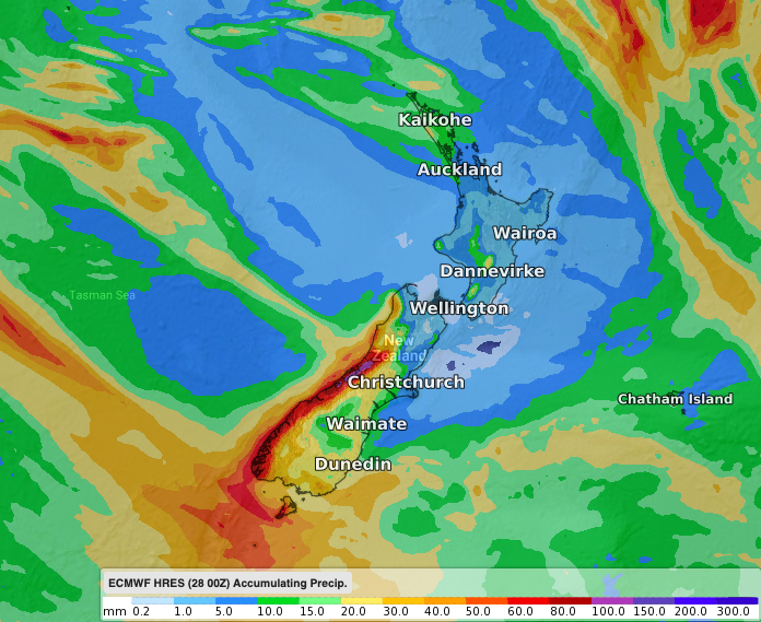
– WeatherWatch.co.nz
Latest Video

Wintry burst of weather: Snow, squally showers then sunshine & frosts
A polar change (another one!) arrives on Friday for the South Island and goes nationwide on Saturday, leaving NZ under…
Related Articles
Wintry burst of weather: Snow, squally showers then sunshine & frosts
A polar change (another one!) arrives on Friday for the South Island and goes nationwide on Saturday, leaving NZ under…

Antarctic southerly for parts of NZ Fri & Sat
For the first time this year a southerly from off Antarctica is heading towards the South Island, followed by more…

Meteors – Your Eyewitness Reports!
WeatherWatch.co.nz receives meteor reports from all over New Zealand and the globe, 24/7/365. **CASUAL COMMENTS**If you’ve seen something in the…

