Next week: Spring-like pattern for half the country will bring rain to both islands
11/01/2018 1:52am

> From the WeatherWatch archives
A day by day forecast for next week — If you’re in the South Island and lower North Island the weather pattern next week will shift more spring-like – and by that we mean cold fronts, windy spells and a variety in daytime temperatures. Rainfall totals, especially on the West Coast and through inland parts of the North Island look average to above average in a number of areas over the next 7 days.
Monday:
A warm sub-tropical north to north east wind flow builds across all of New Zealand ahead of the next cold front. Hot inland with highs around 30 degrees through the South Island’s interior – even Bluff has a high of 27 degrees on Monday.
Tuesday:
A fairly deep low in the Southern Ocean brushes New Zealand and sends a cold front northwards. Strong N to NE winds turn NW and ease a bit. Heavy rain (Rain warning criteria) for the West Coast and patchy rain later in the day with isolated heavy falls moves into the North Island’s western side, heavier falls may develop as the band of rain crosses the North Island over Tuesday night and Wednesday morning with sub-tropical air.
Wednesday:
Cooler south to south west winds with showers and some patchy rain around the South Island. Temperatures take a hit with highs only in the mid teens in Southland.
Thursday:
A cooler southerly for the North Island’s southern and eastern areas with a couple of showers. Warming up a little again in the South Island with mostly dry weather.
Friday:
The next cold front moves into Southland and Fiordland and up the West Coast with heavy falls and another temperature drop behind it.
SUMMER WEATHER CONTINUES FOR THE NORTH OF BOTH ISLANDS:
Not everyone will feel this more spring-like pattern with many in the north of both main islands experience hot weather – and humidity may be ticking up too. It may be a bit cloudier next week with drizzle, showers and even some brief rain – but generally speaking next week looks warm even if a bit cloudy. When the sun comes out it will pack a real punch. The cooler south to south west changes won’t impact these areas as much and the heaviest rain – at least at this stage – looks to be mostly elsewhere (but may change, as is the nature of anything sub-tropical).
7 DAY TREND FOR RAIN COMPARED TO NORMAL (Red = Drier than usual, White = normal rainfall, Blue = wetter than usual)
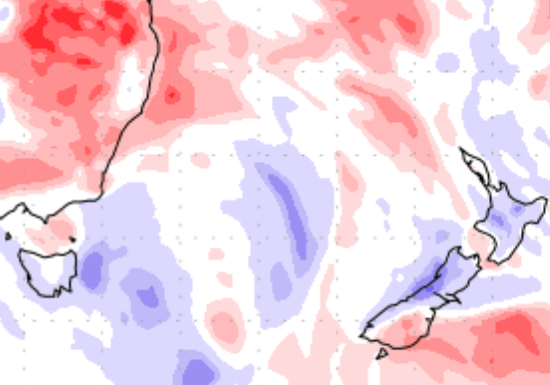
The next 7 days look wet in New Zealand, especially on the West Coast and central North Island.
– WeatherWatch.co.nz
Comments
Latest Video

Snow, rain showers & cold polar southerlies set to return
Friday will be a wintry day across NZ as the next cold front arrives, bringing snow to lower levels of…
Related Articles
Snow, rain showers & cold polar southerlies set to return
Friday will be a wintry day across NZ as the next cold front arrives, bringing snow to lower levels of…

Frosts, late week rain & another cold weekend coming
High pressure will cross NZ over the next few days meaning more cold nights/mornings with frosts, but a nor’wester will…

NZ: Cold & windy, then calm & frosty
Downpours, some squally with the chance of thunderstorms and even small tornadoes are possible for parts of NZ over Friday…


Guest on 11/01/2018 2:07pm
Lets hope so when a low comes out of the north it gives rain to the south island but when one comes out of the south the north island hardly gets any thing…..WTF