More snow and rain coming for NZ but the worst may be behind us now (+4 Maps)
11/04/2018 3:37am

> From the WeatherWatch archives
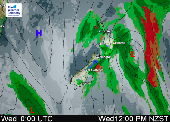
Wednesday is the coldest day of the week for the North Island with the southerly flow firmly blowing across the day. It’s a similar story in the South Island with hail showers and cold winds although conditions are easing back a little today in southern half of the island.
As we head into Thursday two things happen:
Firstly the North Island settles down and warms up a bit as southerlies fade and late westerlies develop.
Secondly the South Island sees yet another cold front with more heavy rain on the West Coast, snow showers on the alpine passes and cold southerlies spreading northwards. Motorists should be aware of changing conditions, especially on Thursday PM and the pre-dawn hours of Friday through the Southern Alps.
This next cold front will reach the North Island at night on Thursday and may have a few localised wind gusts.
High pressure builds as we head into Friday and the weekend which, for the most part, calms things down and slowly starts to warm things back up again.


– Maps by The Weather Company / IBM
– WeatherWatch.co.nz (an official TWC/IBM business partner)
Comments
Latest Video

Temperature changes for some regions ahead of heavy West Coast rain
A nor-wester is about to kick in and it’s coming from out of Australia, boosting temperatures in some regions going…
Related Articles
Temperature changes for some regions ahead of heavy West Coast rain
A nor-wester is about to kick in and it’s coming from out of Australia, boosting temperatures in some regions going…

NZ 7 day forecast: Showers, temp changes and heavy West Coast rain
NZ has a fairly messy forecast over the next 7 days, but the main feature will be heavy rain on…

Cold fronts continue, wind & rain for some Fri/Sat
Wet weather is moving over the North Island today, while the South Island has drier skies – ahead of another…


Guest on 11/04/2018 12:43am
where all we got is a few showers last year was the wettest autmn well this one seems to be the driest….the niwa maps and projections are totally false here in the katkati area its a funny la nina that gives more rain to the south island I must say than the north and east