
> From the WeatherWatch archives
The working week before Easter Weekend sees a fairly settled Monday but a change arrives as soon as Tuesday, mostly for the South Island, thanks to a cold front and Southern Ocean low pressure system.
North Islanders will be mostly unaffected by this next cold front until Wednesday and Thursday when some rain slides up the western side of the island.
Main Weather Highlights:
- On Monday comes a broad area of strong northerly winds in front of an approaching low over the Southern Ocean.
- West Coast and western Southland will be cloudy or have persistent rain because of the northerly flow.
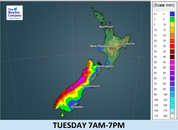
- Tuesday the main part of the front will cross the South Island.
- Heavy rainfall and accumulation is likely on the West Coast on Tuesday – a rain warning is possible.
- Strong northerly winds spread over the entire South Island including Canturbury (especially inland).
- Locally enhanced stronger winds with bigger gusts are more likely through the mountain hills/ranges.


– WeatherWatch.co.nz
Comments
Before you add a new comment, take note this story was published on 25 Mar 2018.
Latest Video

VIDEO: Another big low late week brings severe weather risks to NZ
Severe weather is back in the forecast later this week after we kick off July with high pressure at the…
Related Articles
VIDEO: Another big low late week brings severe weather risks to NZ
Severe weather is back in the forecast later this week after we kick off July with high pressure at the…

VIDEO: NZ 7 Day: One big low, a high, then another big low
Severe weather risks continue around NZ’s two main islands for the rest of Friday and going into Saturday, before conditions…

VIDEO: Severe weather for parts of NZ, ahead of more high pressure
A large low in the Tasman Sea will bring further heavy rain and strong winds to western and southern parts…


Add new comment