
> From the WeatherWatch archives
A large low pressure system in the Tasman Sea draws in an easterly quarter airflow over New Zealand on Monday.
Most of the North Island can expect a cloudy day with areas of rain or showers, parts of Northland may be dry in the morning. Wellington, Wairarapa and Kapiti is looking fairly cloudy, there could be a light shower or two about otherwise mainly dry.
Expect snow about the Central Plateau and the ranges of Gisborne down to 800m, down to 500m about the ranges of Hawkes Bay.
For Nelson, Marlborough and Canterbury conditions are quite cloudy and cold with east to southeasterly winds. There may be a drizzle patch or light shower at times north of about Banks Peninsula through to Marlborough in the east. Any light showers bring the chance of a few snow flakes down to 300 or 200m but due to precipitation levels being very minimal there’s little chance of much if any accumulations.
For the West Coast and Southland conditions are mainly sunny, Central Otago has a mix of sun and cloud then finally coastal Otago has cloudy periods and mainly dry weather with northeasterly breezes.
Temperatures across most of the lower North Island in the high single figure or low double figure arena. Temperatures reaching into the mid teens for Auckland and Northland. High’s ranging from a low 5 degrees about inland parts of the South Island through to 10 degrees for some coastal parts of Canterbury / Marlborough. Nelson, Central Otago, Southland and the West Coast will see afternoon temperatures ranging from 10 to 12 degrees.
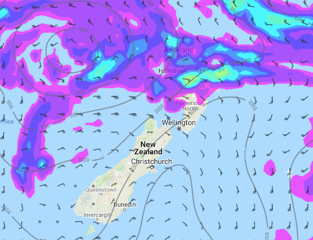
Image: Monday 9th September 2019 3:00pm MSLP / rain map – weathermap.co.nz
WeatherWatch.co.nz
Latest Video

NZ 7 day forecast: Showers, temp changes and heavy West Coast rain
NZ has a fairly messy forecast over the next 7 days, but the main feature will be heavy rain on…
Related Articles
NZ 7 day forecast: Showers, temp changes and heavy West Coast rain
NZ has a fairly messy forecast over the next 7 days, but the main feature will be heavy rain on…

Cold fronts continue, wind & rain for some Fri/Sat
Wet weather is moving over the North Island today, while the South Island has drier skies – ahead of another…

Cold fronts vs high pressure
A cold front is moving up NZ today and into Tuesday, but will fall apart as it heads north and…

