
> From the WeatherWatch archives
A northwesterly airflow lies over New Zealand on Monday, sandwiched between a large low in the south Tasman Sea and an anticyclone to the northeast in the Pacific.
For the upper North Island, conditions are looking dry to start, perhaps even some fog about inland areas then cloud and a few showers move in during the morning especially out east. Showers mostly clear in the evening, the Bay Of Plenty has a mainly dry day till evening however with showers easing there overnight. Mainly sunny weather along the east coast, Taranaki through to Wellington in the west has cloudy areas and the risk of a light shower or two at times otherwise mainly dry.
Cloudy for the West Coast of the South Island with rain, heavy for South Westland then getting heavy about North Westland in the evening. The east coast has sunny areas and some high cloud. Southland sees some rain develop in the morning, clearing afternoon. Otago is dry at first, some rain or showers moves in by midday then clearing late afternoon.
Afternoon temperatures reaching into the high teens or perhaps early twenties for Northland, Auckland, Gisborne and Hawkes Bay. Mid to late teens elsewhere for the North Island. Highs reaching into the late teens for Marlborough and Canterbury, mid teens elsewhere about the South Island.
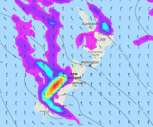
Image: Monday 27th May 2019 3:00pm MSLP / rain map – weathermap.co.nz
WeatherWatch.co.nz
Latest Video

Matariki, the long weekend + the outlook for next week
Wet weather and cloud continues along the eastern side of the country with the heaviest rain now moving into northern…
Related Articles
Matariki, the long weekend + the outlook for next week
Wet weather and cloud continues along the eastern side of the country with the heaviest rain now moving into northern…

More eastern rain, but a drier long weekend coming
Rain continues today along the eastern South Island and lower North Island, coming in from the east with heavy falls….

More heavy rain, snow – but large dry areas, especially as we go into the long weekend
Heavy rain will continue for parts of Canterbury and Marlborough over the next day or two and it will gradually…

