
> From the WeatherWatch archives
A cold southwesterly airflow lies over New Zealand on Monday bringing wet weather to most, conditions will start to ease from afternoon as a ridge starts to push in.
Early rain eases to showers for the upper North Island, dry spells increase from afternoon then becoming mainly dry in the evening as cold southwesterlies tend more to the south. Morning rain for the lower North Island eases to showers and increasing dry spells from afternoon, cold south to southwesterly winds. Showers about Wairarapa spread into Hawkes Bay and Gisborne in the afternoon as southwesterlies freshen. Conditions becoming mainly dry about the lower North Island later in the evening.
Early rain or showers for the upper South Island clearing away for the most part, some rain or showers may linger about the Nelson / Marlborough region till afternoon then clearing. The odd shower peppers Southland and Otago for much of the day, perhaps some inland areas will see long dry spells at times then conditions clearing up in the evening. The West Coast sees any early showers clear then becoming mostly sunny. Winds cold from the southwest but gradually easing.
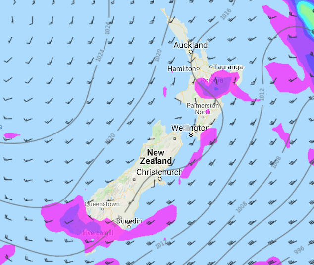
Image: Monday 13th May 2019 3:00pm MSLP / rain map – weathermap.co.nz
WeatherWatch.co.nz
Latest Video

Frosts, clearer skies coming – severe weather possible this weekend
High pressure lies south of NZ today and that placement encourages a colder south-east wind into the North Island bringing…
Related Articles
Frosts, clearer skies coming – severe weather possible this weekend
High pressure lies south of NZ today and that placement encourages a colder south-east wind into the North Island bringing…

NZ: 8 Day outlook as gales & rain ease, high pressure builds
Damaging wind gusts and heavy rain will continue to affect some parts of the North Island and brushing Marlborough today…

Pockets of hit & miss heavy rain, snow moves northwards
Low pressure continues to slowly move across the upper North Island and for some that will bring the sun out,…

