Monday’s weather headlines (x3): Settled today, Northerlies tomorrow, Instability North Island on Wednesday
3/04/2022 7:00pm

> From the WeatherWatch archives
Here’s what is making the weather headlines today.
SETTLED TODAY BUT THINGS ARE ABOUT TO TURN
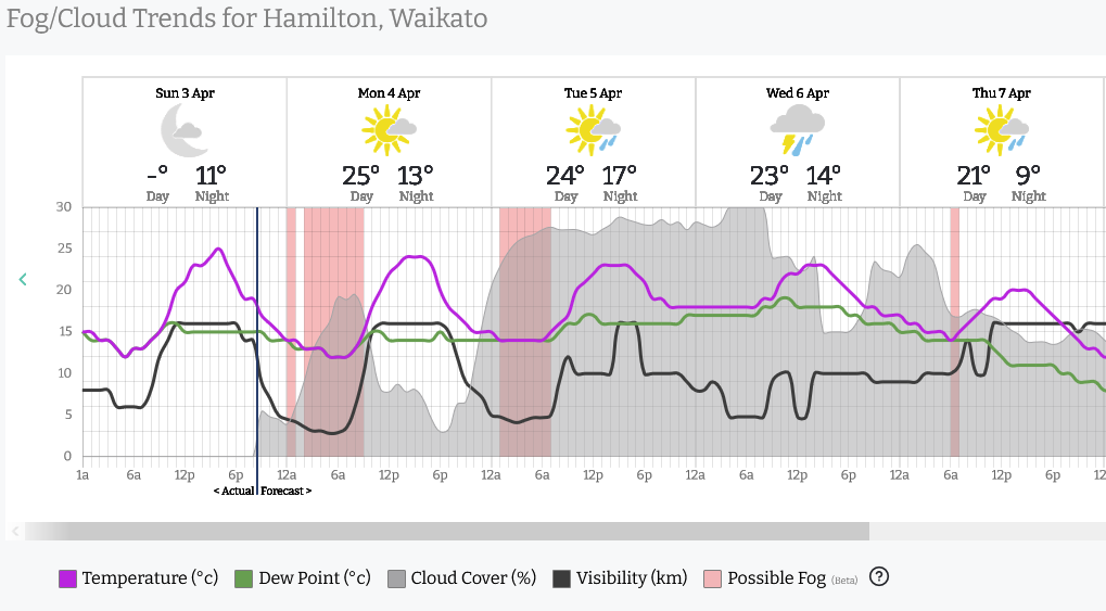
New Zealand is covered by high pressure today bringing mainly settled weather, there could be a fair bit of fog or low cloud about this morning especially for the North Island. Northland through to Waikato should experience a great afternoon though with temperatures likely to get into the mid twenties inland away from the coast.
We start to see showers move into the southwestern corner of the South Island this evening as a warm front moves in, showers spread north along the coast overnight.

Fog graph below, as we can see the Waikato has a fair chance of fog this morning then we break to mostly sunny weather and warm temperatures this afternoon. To check out the fog risk for your location please visit RuralWeather.co.nz, use the search function then click on the “Fog/Cloud” tab.
NORTHERLY AIRFLOW FOR TUESDAY
As the situation starts to close in on Tuesday we see showers or perhaps some rain for western regions meanwhile it is warmer and drier with high cloud in the east. Rain becomes heavy about South Westland from evening and rain becomes widespread for Southland and Otago overnight as a cold front starts it’s march northwards.

FRONT FOR THE NORTH ISLAND ON WEDNESDAY – INSTABILITY
A front is still due to move over the North Island on Wednesday and it may bring some instability with it. The upper North Island has the best chance, mainly in the first half of the way. In the weekend I mentioned that it looked to be a low risk of thunder but I would increase this to a moderate chance now anywhere north of about Waikato / Bay Of Plenty. Northland has the best chance overall but not exactly a high risk at this stage.
The thunder risk for the West Coast tomorrow has dropped a bit further, there still could be a few rumbles about but the chances are not all that high.
Latest Video

More eastern rain, but a drier long weekend coming
Rain continues today along the eastern South Island and lower North Island, coming in from the east with heavy falls….
Related Articles
More eastern rain, but a drier long weekend coming
Rain continues today along the eastern South Island and lower North Island, coming in from the east with heavy falls….

More heavy rain, snow – but large dry areas, especially as we go into the long weekend
Heavy rain will continue for parts of Canterbury and Marlborough over the next day or two and it will gradually…

Large low brings rain, downpours & some snow – gets colder as the week progresses
Low pressure will cross the upper North Island in the days ahead and that set-up actually pushes more heavy rain…

