Monday: Aussie’s big cool down but NZ still mainly milder than average (+2 Maps)
2/08/2018 10:43pm

> From the WeatherWatch archives
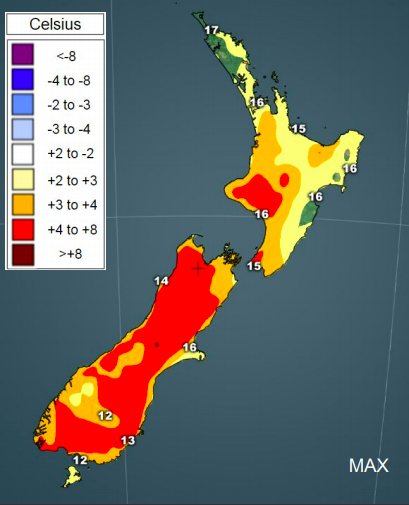
Updated 10:44am — Australia’s run of warmer than average weather is about to briefly stop, but New Zealand has more warmer than average weather on the way.
While not everyone in New Zealand at every moment is warmer than average the general trend recently has sharply been above average. Today (Friday) and Saturday too there may be a few regions with more normal winter temperatures, especially the east of the South Island and up to around Wellington, but again the mild air is returning with nor’easterlies developing this weekend for many, then more west to north west next week, especially one week from now when the air flow could be considerably milder.
Meanwhile a clear cold front is crossing over Australia with the warmer than average run about to (briefly) stop on Monday for most. A huge portion of Australia will be colder than usual on Monday with the exception of Brisbane and parts of coastal Queensland up to Cairns. The cool down sweeps eastwards over Australia but fades in the east on Monday. The warmth creeps back again later next week with 25 degrees expected in Sydney one week from now compared to just 17 degrees this coming Monday.

– WeatherWatch.co.nz
Latest Video

Cold weekend, frosts return with high pressure, then a low late next week
The subantarctic airflow spreads over NZ today/tonight and into Saturday, dropping temperatures nationwide. Snow flurries are possible today to lower…
Related Articles
Cold weekend, frosts return with high pressure, then a low late next week
The subantarctic airflow spreads over NZ today/tonight and into Saturday, dropping temperatures nationwide. Snow flurries are possible today to lower…

Wintry burst of weather: Snow, squally showers then sunshine & frosts
A polar change (another one!) arrives on Friday for the South Island and goes nationwide on Saturday, leaving NZ under…

Antarctic southerly for parts of NZ Fri & Sat
For the first time this year a southerly from off Antarctica is heading towards the South Island, followed by more…

