Mild week next week, double digit overnight lows in Queenstown for example… (+5 maps)
2/05/2019 8:27pm

> From the WeatherWatch archives
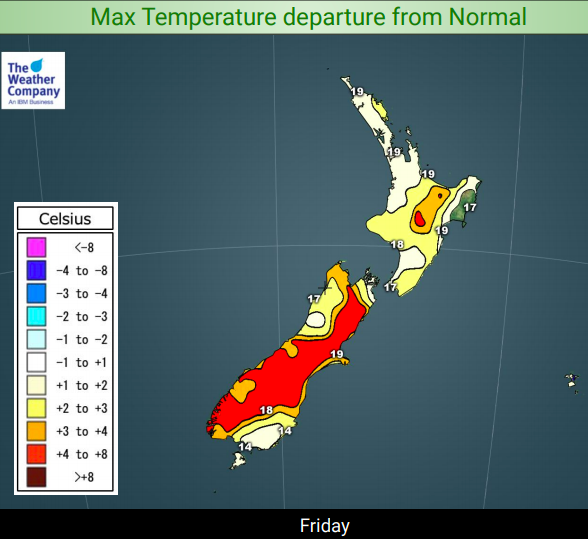
May is kicking off unusually this year. Many regions have a drier than normal week forecast for next week and now it appears warmer than average too with more high pressure than usual.
The procession of large highs crossing New Zealand continues. These larger than average highs have great ‘reach’ – in other words, the air flows coming in to the NZ area can come from as far away as Fiji to the north, Aussie to the west and near Antarctica to the south. The recent placement of these highs is helping to frequently pull down warm sub-tropical air flows across both islands and this happens again this weekend.
To get your head around it better, if you take a high pressure system and draw a line down the middle of it from north to south you’ll find the right hand side of the high often has a southerly flow while the left hand side has a northerly flow…so depending on where the centre of the High is (with the capital “H” in the graphic below) affects whether or not you have a cool southerly as it moves in, calm weather near the centre, or the warmer northerly flow as it departs.

In this graphic above (which by the way is the air pressure map for midnight this Saturday) you can see the cool southerly flow New Zealand has had this week is finally being pushed further east from the country…and as you can see the warmer northerly flow comes in this Saturday night in the deep south, then heads across the rest of the country into early next week. This warmer air flow is coming in from the sub-tropics – that’s how far this current high is reaching.
The result? A much warmer than normal week or two for early May. For example Queenstown has at least three or four nights with double digit overnight lows next week and when it fails to make double digits it will still be around 8 or 9 degrees, well above freezing or frost weather. Even Alexandra in Central Otago has double digit overnight lows in some of the upcoming nights. Tonight the low is 4 degrees which is by far the coldest in the next 10 days – the next lowest overnight temperature forecast for Alexandra in that 10 day time period is a fairly mild 8 degrees this Sunday night. Even Mackenzie Basin in Canterbury’s highlands has at least one night with double digits and frost free weather next week.
In the North Island the centre of the high will be closer so air pressure should be higher and therefore that brings calmer winds – that also means overnight lows will still be a bit chilly but frosts are not forecast at this stage and eventually that mild weather over the South Island reaches regions like Waikato in the north, where overnight lows go from single digits to double digits from around the middle of next week onward.
Not to mention daytime highs next week in both islands will often make it to 18 to 21 degrees across a number of regions.


– WeatherWatch.co.nz
Comments
Before you add a new comment, take note this story was published on 2 May 2019.


Add new comment