
> From the WeatherWatch archives
METSERVICE:
This watch affects people in the following weather forecast districts:
Northland, Auckland, Great Barrier Island, Coromandel Peninsula, Waikato, Bay Of Plenty,
A very unstable airmass lies over the upper North Island. The latest band of heavy showers and squally thunderstorms is expected to move onto Northland later this evening, move through the Auckland area about 4am and continue southeastward passing over the Coromandel Peninsula around 7am to lie over western Bay of Plenty by noon Saturday.
Some of the thunderstorms within this band may be SEVERE, are most likely to occur about northeastern coasts, but may extend right down into the Auckland City area as the band passes. These SEVERE thunderstorms have the potential to produce brief heavy rain, hail of 15-20+mm in diameter, squally wind gusts to 120+km/hr, and there is a risk of a damaging tornado, particularly between the eastern Northland Coast and northern Coromandel Peninsula.
These squally winds and possible small tornadoes may cause some structural damage, including damage to trees and power lines, and make driving hazardous. If any tornados occur, they will only affect very localised areas.
See below for the latest MAPS…
Should severe weather approach, or if you feel threatened, take shelter immediately.
Issued by: Paul Mallinson 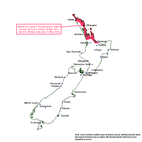
Chart BELOW amended for introduction of risk of severe thunderstorms.
The next band of heavy showers and thunderstorms will move onto the west of the North Island this evening and cross the upper North Island overnight and Saturday morning.
There is a moderate risk of one or two thunderstorms becoming severe over northern Northland later this evening. These may produce brief heavy rain, hail of 10-15mm possible damaging wind gusts of 110+km/hr and a possible small tornado about the northeast coast. Then over the rest of Northland and northern Auckland and extending down into north Taranaki, there is a moderate risk of thunderstorms developing by the end of the period giving localised brief heavy rain, small hail, wind gusts to 90km/hr, and possible small tornados.
There is now a moderate risk of thunderstorms in northwest Marlborough for a few more hours this evening.
A low risk of thunderstorms extends across into Bay of Plenty and Taupo, and down into north Westland, as indicated on the chart.
No thunderstorms or significant convection expected elsewhere.
.gif)
.gif)
Comments
Latest Video

NZ: 8 Day outlook as gales & rain ease, high pressure builds
Damaging wind gusts and heavy rain will continue to affect some parts of the North Island and brushing Marlborough today…
Related Articles
NZ: 8 Day outlook as gales & rain ease, high pressure builds
Damaging wind gusts and heavy rain will continue to affect some parts of the North Island and brushing Marlborough today…

Pockets of hit & miss heavy rain, snow moves northwards
Low pressure continues to slowly move across the upper North Island and for some that will bring the sun out,…

Slow go for northern low & southern cold
For the next few days low pressure will crawl over the upper North Island, driving in rain as far south…


laz on 17/03/2011 4:29am
Got a trip to gt barrier at 1pm tomorrow,do you think it will clear by then so we can get over there
WW Forecast Team on 17/03/2011 4:37am
Hi Laz – this story was from May 2010. No thunderstorms tomorrow for Great Barrier island but a few showers.
– WW
Guest on 14/05/2010 1:24pm
Anything for Kaukapakapa in this front over the next 48 hours?
Guest on 14/05/2010 12:06pm
Been looking to see if we could see any smoke from the big fire at Penrose (As we look out over towards that way from here in East Auckland) & while seeing the smoke, we also have seen a few Lightning flashers in the clouds. (That’s was around 11:40pm / midnight aprox)
Stu on 14/05/2010 7:09am
Sounds lovely, bring it on I say!
Kellie on 14/05/2010 6:52am
Hey Phil,
Andy chance of Te Aroha getting any thunder action in the next 48 hours?
WW Forecast Team on 14/05/2010 9:15am
Hey Kellie – best shot is during Saturday. Can’t give you a specific time sorry as the fronts are fragmented…dying, rebirthing, dying again… but I’d say anywhere between 9am Saturday and 9am Sunday there is a chance. A better chance near Thames and Port Waikato though.
Good luck!
Guest on 29/11/2010 3:55am
O.K!!!!!!
Boring……
I was Researching on tornadoes and i need just info on tornadoes…..
I’m in inter pa……
LOL…….
BORED……….