Large complicated low may linger for 10+ days affecting both NZ & Australia (+5 Maps)
8/05/2018 10:38pm

> From the WeatherWatch archives
A complicated area of low pressure is developing today in the western Tasman Sea and will deepen over the weekend bringing some isolated areas of severe weather in New Zealand and widespread severe weather across south eastern Australia.
The low is going to be large enough to cover much of the Tasman Sea with the worst winds being on the Australian zone in the ‘squash zone’ between this Tasman Sea low and the incoming high from western Australia. The low itself, while very large, isn’t considered to be a ‘storm’ generally speaking.
This low will be so large it will fracture the rain clouds and encourage a fairly calm large centre, with the windiest weather in New Zealand also caused by a different ‘squash zone’. Unlike Aussie’s colder southerly squash zone New Zealand’s will be more from the northerly quarter (and sub-tropical) and will be caused by the high we currently have over us departing away slowly than the low is trying to move in. Heavy downpours are expected this weekend in northern New Zealand and then easing on Monday, along with these gusty winds. There may also be gusty winds through Westland this week as today’s high starts to depart.
Next week this large Tasman Sea low will start to shrink in size for a time based on reliable modelling and slowly starts to meander towards New Zealand – but a possible Antarctic blast next week over Tasmania and south eastern Australia (next Thursday and Friday at this stage) may energise this low once again. It’s unclear if New Zealand will also be hit by the colder air, or simply the warmer rain making low. It’s now ‘one to watch’ and shows the weather pattern next week will be quite different to the more settled one around large parts of New Zealand this week.


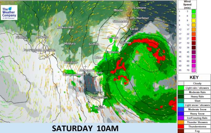

 – Noon Next Friday (May 18th) shows the same area of low pressure being energised by a southerly on the Australian side. This map will likely change but shows the set up is large and complicated. Model by GFS. (ECMWF out of Europe shows a similar set up too).
– WeatherWatch.co.nz
Latest Video

Cold weekend, frosts return with high pressure, then a low late next week
The subantarctic airflow spreads over NZ today/tonight and into Saturday, dropping temperatures nationwide. Snow flurries are possible today to lower…
Related Articles
Cold weekend, frosts return with high pressure, then a low late next week
The subantarctic airflow spreads over NZ today/tonight and into Saturday, dropping temperatures nationwide. Snow flurries are possible today to lower…

Wintry burst of weather: Snow, squally showers then sunshine & frosts
A polar change (another one!) arrives on Friday for the South Island and goes nationwide on Saturday, leaving NZ under…

Antarctic southerly for parts of NZ Fri & Sat
For the first time this year a southerly from off Antarctica is heading towards the South Island, followed by more…

