InfoGraphic: The Main Weather News Highlights across NZ: Wed, Thu, Fri
4/07/2017 7:00pm

> From the WeatherWatch archives
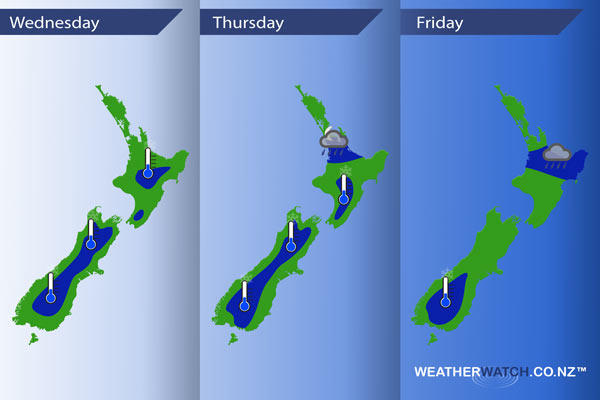
A ridge of high pressure lies over New Zealand today bringing mainly settled conditions, Thursday sees an occluded frontal zone lying over the upper North Island while an easterly quarter airflow flows over the rest of the country. The occluded front moves a little further south on Friday, easterlies for everyone else.
Wednesday
Blue – A frosty start to the day for some, especially the South Island inland where some isolated spots may dip into -6 degree territory.
Thursday
Blue – An frontal zone may bring the odd heavy shower or area of rain about Auckland from evening then a little further south overnight.
A frosty start again for some mainly inland away from the coast. The coldest overnight lows will be about inland South Island areas.
Friday
Blue – A few heavy showers or areas of rain ease about the Waikato and Bay Of Plenty in the morning moving into East Cape / Gisborne around midday, easing there in the evening.
Fairly cloudy skies keep frosts away for most however the lower South Island sees quite cold temperatures around dawn.
– Please note, the idea behind this update is to focus on the main weather highlights, which is why not all regions are mentioned.
For specific 10 day information for your city, town, rural community or island please see the 1500 forecasts on our homepage!
– Aaron Wilkinson, WeatherWatch.co.nz
Comments
Before you add a new comment, take note this story was published on 4 Jul 2017.
Latest Video

VIDEO: Severe weather late week as next low arrives
Another week, another big low is on the way from the Tasman Sea bringing wind and rain later this week,…
Related Articles
VIDEO: Severe weather late week as next low arrives
Another week, another big low is on the way from the Tasman Sea bringing wind and rain later this week,…

NZ VIDEO: High pressure gives way to windy, wetter, weather late week
Storms south of Australia will start to affect NZ later this week as an active cold front moves in, followed…

(VIDEO) NZ 7 Day: Variety in the weather, but Southern Ocean storms waking up
Low pressure moves in to NZ from the Tasman Sea this weekend and completely falls apart – bringing downpours and…


Add new comment