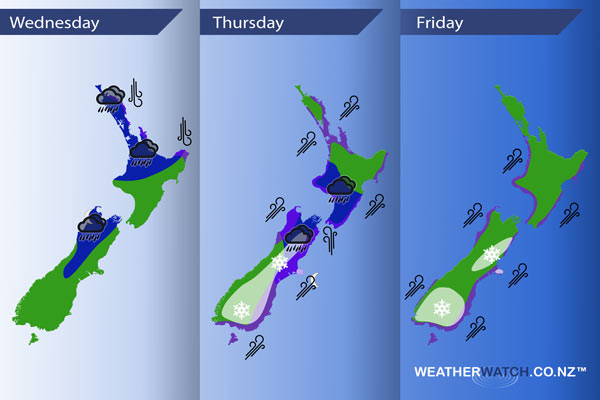
InfoGraphic: The Main Weather News Highlights across NZ: Wed, Thu, Fri
16/05/2017 7:00pm

> From the WeatherWatch archives
A front pushes over New Zealand from the west mainly during the morning today however not clearing some eastern parts of the North Island till later on. A northerly quarter airflow tends southerly about the lower South Island this afternoon meanwhile a deep low is centred just to the west. This low moves over central New Zealand on Thursday allowing in a very cold southwest flow which continues on Friday and gets a bit colder for a time.
Wednesday
Blue – Heavy rain about the upper North Island eases during the afternoon, perhaps not easing about western East Cape till evening however.
As a southerly airflow builds over the South Island later in the day some rain may become heavy about the Canterbury and Marlborough high country, also about Nelson / Tasman.
Purple – Northerly winds about northeastern coastal fringes of the North Island may be brisk / strong at times today, easing from afternoon.
Thursday
Blue – Rain about the upper South Island eases around midday, rain about the lower North Island becoming heavy at times during the morning then easing late afternoon.
Purple – South to southwesterly winds will be strong with a chance of gales about many coastal parts of New Zealand during the day.
White – During the afternoon a very cold southwest change moves onto the lower South Island then spreads northwards into Canterbury by evening then Marlborough for a brief time overnight. It must be noted that while cold and strong this change doesn’t hang around very long. Some snow to 400m about the lower South Island, 500m about Canterbury and 600m about Marlborough as this front moves through. Areas of snow flurries may vary + or – 100m.
Friday
Purple – Strong cold southwesterly winds continue about coastal parts of the country during the day with winds likely gusting to gale at times.
White – Late afternoon a very cold southwest change moves onto the lower South Island which reaches Canterbury later in the evening or overnight. This change will be colder then Thursday’s bringing snow flurries about the lower South Island to low levels (100 – 200m) and perhaps to 400 or maybe even 300m about Canterbury. Due to the nature of this particular change some parts of North Otago, South Canterbury and perhaps up into parts of Mid Canterbury may be fairly sheltered meaning little if any snow falling in these areas. Amounts of snow may be in the range of 5 to 10cm about the lower South Island, only 1 to 2cm about Canterbury meaning it may not settle at all or only for a brief time.
– Please note, the idea behind this update is to focus on the main weather highlights, which is why not all regions are mentioned.
For specific 10 day information for your city, town, rural community or island please see the 1500 forecasts on our homepage!
– Aaron Wilkinson, WeatherWatch.co.nz
Latest Video

Wintry weather coming: Snow, rain, wind & sunshine
A cold front is moving into NZ from Friday to Sunday with low pressure developing west of NZ and then…
Related Articles

Polar airflow + northern low = pockets of heavy rain & snow
A colder change is coming – and so too is a large low which will develop and grow over northern…
Wintry weather coming: Snow, rain, wind & sunshine
A cold front is moving into NZ from Friday to Sunday with low pressure developing west of NZ and then…

ClimateWatch: JULY outlook & what El Niño means for NZ
El Niño is officially here and still getting stronger in the months ahead, but it’s harder to notice its effects…

