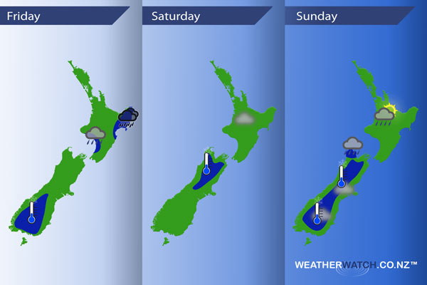
InfoGraphic: The Main Weather News Highlights across NZ: Fri, Sat, Sun
7/07/2017 3:18am

> From the WeatherWatch archives
A low pressure system moves over the North Island today while northeasterlies flow over the South Island. A northerly airflow develops on Saturday then on Sunday a low moves over the North Island while the South Island has mainly light winds.
Friday
Blue – Rain with heavy falls about East Cape / Gisborne and perhaps Hawkes Bay then easing from afternoon. There may also be some heavy rain about the lower North Island in the west, easing from afternoon.
Fairly cloudy skies keep frosts away for most however the lower South Island sees quite cold temperatures around dawn, -4 to -6 degrees looks possible for many about inland Otago. Possibly as low as -10 degrees again about Mount Cook.
Saturday
Blue – A touch of frost about the upper South Island in the morning, nothing major.
There may also be a risk of fog to start the day about the Waikato and perhaps Auckland.
Sunday
Blue – A frosty start about the inner South Island, also a chance of fog inland and in the east during the morning.
Tasman may see heavy showers in the morning then easing from afternoon.
About the Waikato and Taranaki there may be heavy showers at times in the afternoon then easing in the evening.
– Please note, the idea behind this update is to focus on the main weather highlights, which is why not all regions are mentioned.
For specific 10 day information for your city, town, rural community or island please see the 1500 forecasts on our homepage!
– Aaron Wilkinson, WeatherWatch.co.nz
Comments
Before you add a new comment, take note this story was published on 7 Jul 2017.
Latest Video

VIDEO: Severe weather late week as next low arrives
Another week, another big low is on the way from the Tasman Sea bringing wind and rain later this week,…
Related Articles
VIDEO: Severe weather late week as next low arrives
Another week, another big low is on the way from the Tasman Sea bringing wind and rain later this week,…

NZ VIDEO: High pressure gives way to windy, wetter, weather late week
Storms south of Australia will start to affect NZ later this week as an active cold front moves in, followed…

(VIDEO) NZ 7 Day: Variety in the weather, but Southern Ocean storms waking up
Low pressure moves in to NZ from the Tasman Sea this weekend and completely falls apart – bringing downpours and…


Add new comment