
> From the WeatherWatch archives
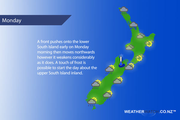
A front moves onto the lower South Island early on Monday morning then moves northwards however it quickly weakens as it does so, meanwhile a large low brews in the north Tasman Sea.
A mainly cloudy day about the upper North Island with showers or some drizzle at times, easing in the afternoon for some. A drizzle patch or two may extend down into the Waikato and Bay Of Plenty otherwise looking mainly dry there. Further south the lower North Island is looking mainly dry but expect plenty of high cloud, Kapiti sees a few showers feed in from the west.
A mainly sunny day for Nelson and Marlborough although late afternoon some cloud increases about Marlborough as winds tend southerly. Rain to start early on for the West Coast then quickly easing and clearing around midday, some sun starting to break through from afternoon.
Canterbury starts off with some sun then cloud quickly increases as winds tend southerly, some drizzle possible about inland areas from afternoon otherwise mainly dry. Southland and Otago see early morning showers clear then sunny areas increase, southwesterlies die out in the morning.
Blue – Heavy form of precipitation or cold temperatures, typically below 1 to 2 degrees celsius.
Purple – Strong winds.
Yellow – Temperatures around the mid 20 degree mark or over.
Not all regions and towns have been mentioned above. For specific 10 day information for your city, town, rural community or island please see the 1500 forecasts on our homepage!
– Aaron Wilkinson, WeatherWatch.co.nz
Latest Video

Wintry weather coming: Snow, rain, wind & sunshine
A cold front is moving into NZ from Friday to Sunday with low pressure developing west of NZ and then…
Related Articles

Polar airflow + northern low = pockets of heavy rain & snow
A colder change is coming – and so too is a large low which will develop and grow over northern…
Wintry weather coming: Snow, rain, wind & sunshine
A cold front is moving into NZ from Friday to Sunday with low pressure developing west of NZ and then…

ClimateWatch: JULY outlook & what El Niño means for NZ
El Niño is officially here and still getting stronger in the months ahead, but it’s harder to notice its effects…

