InfoGraphic: The Big Picture for Wednesday / Thursday
24/09/2019 7:00pm

> From the WeatherWatch archives
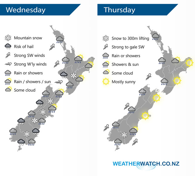
A cold west to southwesterly airflow lies over the country today and on Thursday.
West to southwesterly winds freshen over much of the North Island today, expect showers for all western areas, heavy at times from midday. Snow lowers to 400m overnight about the Central Plateau. Showers for Southland and the West Coast of the South Island, heavy at times with a risk of hail. Conditions may be dry at first for Otago then showers with a risk of hail moving in by midday, showers move into Canterbury mid afternoon. Just the risk of a shower about Marlborough by evening. Snow to 400m about Southland and Otago, possibly lowering to 200m for a time overnight then easing. Snow lowers in the ranges of Canterbury down to 400m by evening.
Expect showers for much of the western North Island on Thursday, long dry periods for the Bay Of Plenty. Mostly sunny conditions for the east coast. The West Coast of the South Island, Southland and Otago has rain or showers, snow to 400m or maybe even 300m in the morning with a risk of hail then lifting during the day. Mostly sunny for Canterbury and Marlborough, a few evening showers move into Canterbury as westerlies tend southwest.
By Weather Analyst Aaron Wilkinson – WeatherWatch.co.nz
Latest Video

NZ: 8 Day outlook as gales & rain ease, high pressure builds
Damaging wind gusts and heavy rain will continue to affect some parts of the North Island and brushing Marlborough today…
Related Articles
NZ: 8 Day outlook as gales & rain ease, high pressure builds
Damaging wind gusts and heavy rain will continue to affect some parts of the North Island and brushing Marlborough today…

Pockets of hit & miss heavy rain, snow moves northwards
Low pressure continues to slowly move across the upper North Island and for some that will bring the sun out,…

Slow go for northern low & southern cold
For the next few days low pressure will crawl over the upper North Island, driving in rain as far south…

