InfoGraphic: The Big Picture for Wednesday / Thursday
30/07/2019 7:00pm

> From the WeatherWatch archives
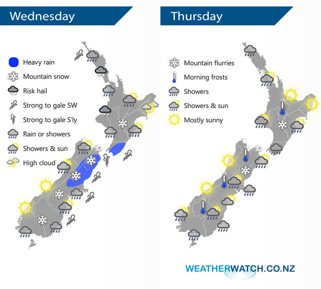
A cold front / pool of air moves off the upper South Island this morning and onto the North Island this afternoon and evening, conditions settle a little further south but still quite cold. Cold southwesterlies lie over the country on Thursday.
Showers for the western North Island today, becoming heavy this afternoon with a risk of thunder and hail then easing later on. Snow lowers to 500m about the Central Plateau. Rain or showers moves into Wairarapa this afternoon then further north in the evening with a southwest change. Rain about the upper northeastern South Island may be heavy then easing to showers in the afternoon, snow to 400m. The West Coast is mainly sunny, morning rain about North Westland clears. Showers about the far south for much of the day, snow flurries to 400 or possibly even 300m at times. South to southwesterly winds will be strong to gale about coastal areas.
Showers about Northland ease in the evening on Thursday, morning showers for Auckland then sunny spells develop. Showers for Taranaki in the west down to Wellington then up the east coast through to about Mahia Peninsula, shower activity most intense for Wellington and Wairarapa. Snow flurries to 500m about the Central Plateau. A sunny day for the West Coast of the South Island and Nelson / Marlborough. The interior of the eastern South Island may see a few early showers then dry with sunny spells, North Canterbury and Banks Peninsula sees showers gradually ease then mostly clearing in the evening, snow flurries to 400m and lifting during the day. A few showers pepper the far south for most of the day, snow flurries stick above 500 to 600m.
By Weather Analyst Aaron Wilkinson – WeatherWatch.co.nz
Latest Video

Matariki, the long weekend + the outlook for next week
Wet weather and cloud continues along the eastern side of the country with the heaviest rain now moving into northern…
Related Articles
Matariki, the long weekend + the outlook for next week
Wet weather and cloud continues along the eastern side of the country with the heaviest rain now moving into northern…

More eastern rain, but a drier long weekend coming
Rain continues today along the eastern South Island and lower North Island, coming in from the east with heavy falls….

More heavy rain, snow – but large dry areas, especially as we go into the long weekend
Heavy rain will continue for parts of Canterbury and Marlborough over the next day or two and it will gradually…

