InfoGraphic: The Big Picture for Wednesday / Thursday
16/07/2019 7:00pm

> From the WeatherWatch archives
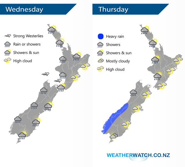
A blustery west to southwesterly airflow lies over the country today tending northwest on Thursday with a front moving onto the western South Island from afternoon.
Showers for most of today about the western North Island, some may be heavy at times then easing overnight. Mainly sunny in the east after any morning high cloud clears. Showers may be heavy at times with thunderstorms and hail for the western South Island, easing in the evening. Southland and Otago are mainly dry however expect a few clearing showers for North Otago in the morning, the odd shower moves into Southland from afternoon. Canterbury sees showers develop this morning south of Banks Peninsula, moving further northwards in the afternoon.
Showers at times for western regions on Thursday, rain becoming heavy about South Westland from afternoon. Mainly dry out east with some high cloud.
By Weather Analyst Aaron Wilkinson – WeatherWatch.co.nz
Latest Video

Matariki, the long weekend + the outlook for next week
Wet weather and cloud continues along the eastern side of the country with the heaviest rain now moving into northern…
Related Articles
Matariki, the long weekend + the outlook for next week
Wet weather and cloud continues along the eastern side of the country with the heaviest rain now moving into northern…

More eastern rain, but a drier long weekend coming
Rain continues today along the eastern South Island and lower North Island, coming in from the east with heavy falls….

More heavy rain, snow – but large dry areas, especially as we go into the long weekend
Heavy rain will continue for parts of Canterbury and Marlborough over the next day or two and it will gradually…

