
> From the WeatherWatch archives
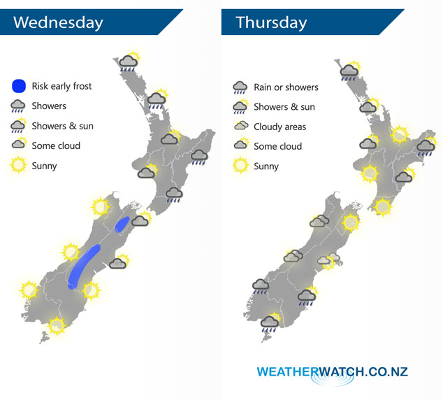
An anticyclone lies across the South Island today, expect southeasterlies further north. An anticyclone covers most of New Zealand on Thursday, a cold front moves onto the lower South Island in the morning reaching the upper South Island later in the evening / overnight.
Sunny spells for the upper North Island today, chance of a shower or two about Northland and Auckland mainly afternoon. Mostly cloudy along the east coast with the odd shower or drizzle patch. The South Island has a mostly sunny day, some morning cloud in the northeast breaks away.
Morning cloud or showers clears the upper North Island on Thursday then mostly sunny, showers ease and clear Gisborne in the afternoon. Morning cloud clears Hakwes Bay then mostly sunny. A sunny day for Wairarapa, Wellington and up through to Taranaki. Rain or showers (possibly heavy) moves onto the lower South Island during the morning, showers move into Canterbury later in the evening.
By Weather Analyst Aaron Wilkinson – WeatherWatch.co.nz
Latest Video

Cold weekend, frosts return with high pressure, then a low late next week
The subantarctic airflow spreads over NZ today/tonight and into Saturday, dropping temperatures nationwide. Snow flurries are possible today to lower…
Related Articles
Cold weekend, frosts return with high pressure, then a low late next week
The subantarctic airflow spreads over NZ today/tonight and into Saturday, dropping temperatures nationwide. Snow flurries are possible today to lower…

Wintry burst of weather: Snow, squally showers then sunshine & frosts
A polar change (another one!) arrives on Friday for the South Island and goes nationwide on Saturday, leaving NZ under…

Antarctic southerly for parts of NZ Fri & Sat
For the first time this year a southerly from off Antarctica is heading towards the South Island, followed by more…

