InfoGraphic: The Big Picture for Wednesday / Thursday
26/03/2019 6:00pm

> From the WeatherWatch archives
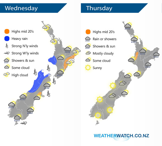
A front slowly moves off the upper South Island then pushes onto the lower North Island during today, a ridge of high pressure starts to push onto the South Island later in the day. An anticyclone lies over the South Island on Thursday meanwhile the front further north gradually weakens.
Thickening high cloud for the upper / western North Island today, rain moves into the southwest in the afternoon with heavy falls possible about Taranaki by evening. The east coast is mainly dry, some rain pushes into Wairarapa late afternoon. Heavy rain eases about the upper / western South Island from afternoon, rain spilling into Canterbury and Marlborough clears up during the afternoon. Rain or showers about the lower South Island ease in the afternoon and mostly clears by evening.
Cloudy for the east coast of the North Island on Thursday, expect rain or showers especially about Hawkes Bay and Gisborne. Morning rain for the upper North Island, isolated showers from afternoon possibly heavy then easing later on. The South Island is mostly sunny however expect some cloud for Canterbury, Marlborough and Nelson; breaking to some sun about coastal areas in the afternoon.
By Weather Analyst Aaron Wilkinson – WeatherWatch.co.nz
Latest Video

Colder nights/mornings, polar change coming Sun/Mon
The nights and mornings ahead will be colder in a number of regions – but an even colder change is…
Related Articles
Colder nights/mornings, polar change coming Sun/Mon
The nights and mornings ahead will be colder in a number of regions – but an even colder change is…

Frosts, clearer skies coming – severe weather possible this weekend
High pressure lies south of NZ today and that placement encourages a colder south-east wind into the North Island bringing…

NZ: 8 Day outlook as gales & rain ease, high pressure builds
Damaging wind gusts and heavy rain will continue to affect some parts of the North Island and brushing Marlborough today…

