InfoGraphic: The Big Picture for Wednesday / Thursday
4/12/2018 6:00pm

> From the WeatherWatch archives
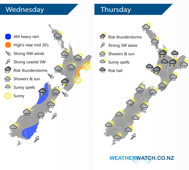
A northwesterly airflow changes to the southwest over the South Island today heralding in cooler temperatures. These cooler temperatures arrive in the North Island on Thursday, showers gradually clear from the south then expect mainly settled weather on Friday.
The odd shower for much of the western North Island today, mainly sunny for the east coast. Heavy showers with possible thunder moving into Kapiti this afternoon. Rain or showers about Southland and Otago spreading northwards along the east coast during today with a cold southwest change. Rain may be heavy with thunder this morning for North Westland.
Showers clearing for the lower South Island in the morning on Thursday, lingering for some upper South Island areas (mainly inland and in the west) through till evening. Showers for the North Island with heavy thundery falls possible, clearing later in the evening or overnight for western regions.
By Weather Analyst Aaron Wilkinson – WeatherWatch.co.nz
Latest Video

Matariki, the long weekend + the outlook for next week
Wet weather and cloud continues along the eastern side of the country with the heaviest rain now moving into northern…
Related Articles
Matariki, the long weekend + the outlook for next week
Wet weather and cloud continues along the eastern side of the country with the heaviest rain now moving into northern…

More eastern rain, but a drier long weekend coming
Rain continues today along the eastern South Island and lower North Island, coming in from the east with heavy falls….

More heavy rain, snow – but large dry areas, especially as we go into the long weekend
Heavy rain will continue for parts of Canterbury and Marlborough over the next day or two and it will gradually…

