InfoGraphic: The Big Picture for Wednesday / Thursday
16/10/2018 6:00pm

> From the WeatherWatch archives
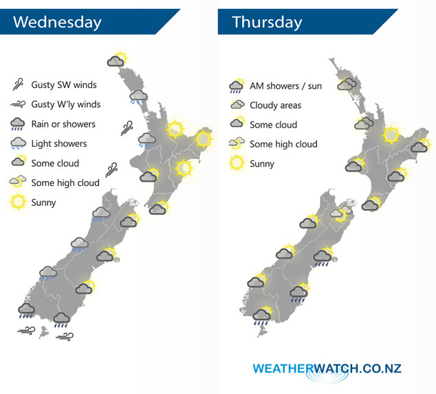
A large anticyclone sits in the Tasman Sea today, a west to southwesterly airflow moving around this high flows over the country. This anticyclone spreads out over New Zealand on Thursday however just before it does a front races northwards over the South Island in the morning. This front will weaken as it moves northwards, moving onto the lower North Island around midday.
Quite cloudy for western New Zealand today, the odd light shower possible also especially for the western South Island. Sunnier conditions for the east of the North Island however some cloud moves into the Wairarapa during the morning and perhaps further north in the afternoon as light winds tend to the south. Showers for Southland, a mix of sun and cloud for the rest of the eastern South Island.
Mostly cloudy for the upper North Island on Thursday, there may be a light shower in the morning then areas of sun breaking through from mid or late afternoon. The Bay Of Plenty has a mostly sunny day. Cloud about Taranaki southwards in the west breaks to sun in the afternoon as southeasterlies develop. A mostly sunny morning from Wellington through to Gisborne, southerlies pick up about Wellington late morning quickly moving into Gisborne early afternoon bringing some cloud.
Morning cloud for the West Coast of the South Island with the chance of a light shower, sun breaks through from afternoon. Morning high cloud for Nelson and Marlborough then mostly sunny with onshore winds. Canterbury sees a few morning showers then sun breaks through from afternoon, southerlies tend northeast by evening. Early showers clear about Southland and Otago then becoming mostly sunny in the afternoon with easing southwesterly winds.
By Weather Analyst Aaron Wilkinson – WeatherWatch.co.nz
Latest Video

Matariki, the long weekend + the outlook for next week
Wet weather and cloud continues along the eastern side of the country with the heaviest rain now moving into northern…
Related Articles
Matariki, the long weekend + the outlook for next week
Wet weather and cloud continues along the eastern side of the country with the heaviest rain now moving into northern…

More eastern rain, but a drier long weekend coming
Rain continues today along the eastern South Island and lower North Island, coming in from the east with heavy falls….

More heavy rain, snow – but large dry areas, especially as we go into the long weekend
Heavy rain will continue for parts of Canterbury and Marlborough over the next day or two and it will gradually…

