InfoGraphic: The Big Picture for Wednesday / Thursday
12/06/2018 7:00pm

> From the WeatherWatch archives
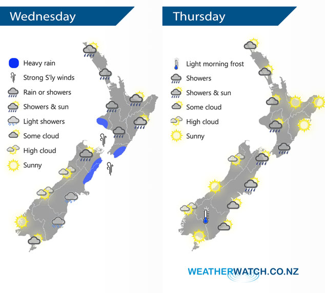
A low pressure system is centred over the North Island today bringing unsettled weather to most parts of the country, Southland and Fiordland see the best weather. A ridge of high pressure moves in on Thursday.
Today is still unsettled for a majority of New Zealand, some heavy rain possible for coastal northeastern parts of the South Island this morning then easing. Some heavy rain also possible about Taranaki and the Wairarapa. Southerly winds will likely be strong through Cook Strait.
Morning showers clear most parts of New Zealand on Thursday however a shower or two may linger about the Manawatu and Wairarapa through into the afternoon. Generally fairly settled otherwise, there is the risk of a light shower or two at times from Northland and down along the western side of the North Island however the majority of the time it is looking to be dry. A ridge of high pressure brings the chance of a light morning frost about Central Otago.
By Weather Analyst Aaron Wilkinson – WeatherWatch.co.nz
Latest Video

ClimateWatch: JULY outlook & what El Niño means for NZ
El Niño is officially here and still getting stronger in the months ahead, but it’s harder to notice its effects…
Related Articles
ClimateWatch: JULY outlook & what El Niño means for NZ
El Niño is officially here and still getting stronger in the months ahead, but it’s harder to notice its effects…

Low pressure heading to NZ this weekend & into next week
Many regions have settled weather at the moment with frosts as far north as Auckland this morning, but still some…

Colder nights/mornings, polar change coming Sun/Mon
The nights and mornings ahead will be colder in a number of regions – but an even colder change is…

