
> From the WeatherWatch archives
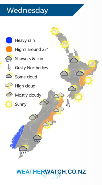
A northwesterly airflow lies over most of New Zealand on Wednesday, a front pushes onto the lower South Island later in the afternoon bringing in a cool change.
Wednesday starts to see a building northwesterly airflow, this brings some cloud to the western North Island while elsewhere stays mainly sunny.
Cloudy for the West Coast of the South Island with heavy rain for Fiordland pushing northwards overnight, mainly dry in the east with warm temperatures and some high cloud. Showers gradually move into Southland and Otago as cool southwesterlies develop late afternoon / evening.
By Weather Analyst Aaron Wilkinson – WeatherWatch.co.nz
Latest Video

NZ: 8 Day outlook as gales & rain ease, high pressure builds
Damaging wind gusts and heavy rain will continue to affect some parts of the North Island and brushing Marlborough today…
Related Articles
NZ: 8 Day outlook as gales & rain ease, high pressure builds
Damaging wind gusts and heavy rain will continue to affect some parts of the North Island and brushing Marlborough today…

Pockets of hit & miss heavy rain, snow moves northwards
Low pressure continues to slowly move across the upper North Island and for some that will bring the sun out,…

Slow go for northern low & southern cold
For the next few days low pressure will crawl over the upper North Island, driving in rain as far south…

