
> From the WeatherWatch archives
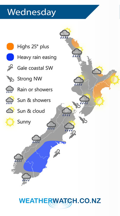
The main low pressure system associated with Ex Tropical Cyclone Gita lies east of the South Island on Wednesday meanwhile another low sits west of the South Island. A northwest airflow lies over the North Island.
A few showers for western parts of the North Island on Wednesday, more likely Taranaki southwards but a few are possible further north mainly in the afternoon. Any morning cloud clears the Bay Of Plenty then mostly sunny.
Rain or showers for most South Island regions, heavy rain Banks Peninsula southwards eases in the morning, not easing about parts of Otago till late afternoon / evening. Expect gale southwesterly winds for the coastal parts of the eastern South Island, severe gales possible out on Banks Peninsula. These winds will gradually ease during the day.
Strong northwesterlies through Cook Strait ease in the afternoon then winds change southerly.
By Weather Analyst Aaron Wilkinson – WeatherWatch.co.nz
Comments
Latest Video

Low pressure heading to NZ this weekend & into next week
Many regions have settled weather at the moment with frosts as far north as Auckland this morning, but still some…
Related Articles
Low pressure heading to NZ this weekend & into next week
Many regions have settled weather at the moment with frosts as far north as Auckland this morning, but still some…

Colder nights/mornings, polar change coming Sun/Mon
The nights and mornings ahead will be colder in a number of regions – but an even colder change is…

Frosts, clearer skies coming – severe weather possible this weekend
High pressure lies south of NZ today and that placement encourages a colder south-east wind into the North Island bringing…


Guest on 20/02/2018 4:53am
Does the Low look positioned west of Taranaki at 5pm?
Further North, further North than forcast?
WW Forecast Team on 20/02/2018 5:02am
Hi there yes it has moved a little further north – but the centre is also expanding wider. Still may make landfall in the NW South Island but until it properly shows up on rain radar a little hard to be precise. Likely to happen in the next 1 to 3 hours at this stage (a little earlier than originally expected). That’s the best thinking as of 6pm anyway!
Cheers
WW