InfoGraphic: The Big Picture for Tuesday / Wednesday
2/03/2020 6:00pm

> From the WeatherWatch archives
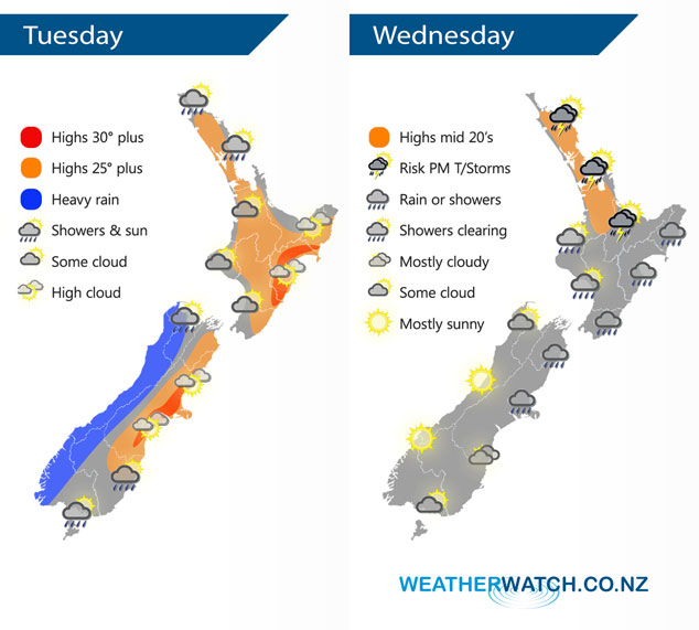
A front pushes northwards over the South Island today reaching the lower North Island overnight, winds from the north or northwest ahead of the front, changing southwest in behind. This front continues over the North Island on Wednesday with a ridge building further south.
Sunny spells for the upper / western North Island today, chance of a light shower or two for some exposed eastern parts of Northland and Auckland. Rain moves onto the southwestern corner of the North Island overnight. Heavy rains pushes northwards along the West Coast of the South Island, easing evening with a southwest change. Mainly dry in the east with some high cloud, spots of rain spread into Marlborough however in the evening. Also Southland and Otago sees some brief rain then a few showers with a southwest change.
A band of rain / showers moves northeast over the North Island on Wednesday, showers may become heavy with thunderstorms in isolated spots from Northland down through to the Waikato / Bay Of Plenty then easing evening. Morning showers clear in the southwest then some sun breaks through, mostly cloudy in the east with rain or showers. Sunny for the South Islands West Coast, showers in the northeast gradually ease mostly clearing in the afternoon but one or two may linger till evening. Morning cloud in the southeast gradually breaks away.
Weather Analyst Aaron Wilkinson – WeatherWatch.co.nz
Comments
Latest Video

Matariki, the long weekend + the outlook for next week
Wet weather and cloud continues along the eastern side of the country with the heaviest rain now moving into northern…
Related Articles
Matariki, the long weekend + the outlook for next week
Wet weather and cloud continues along the eastern side of the country with the heaviest rain now moving into northern…

More eastern rain, but a drier long weekend coming
Rain continues today along the eastern South Island and lower North Island, coming in from the east with heavy falls….

More heavy rain, snow – but large dry areas, especially as we go into the long weekend
Heavy rain will continue for parts of Canterbury and Marlborough over the next day or two and it will gradually…


josh on 2/03/2020 7:12pm
i am proud of you guys