InfoGraphic: The Big Picture for Tuesday / Wednesday
25/11/2019 6:00pm

> From the WeatherWatch archives
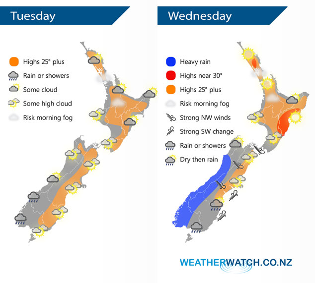
A northwesterly airflow builds over the South Island today, a ridge of high pressure lies over the North Island. A northwesterly airflow lies over New Zeland on Wednesday, a front straddles the far south bringing some rain to Southland and Fiordland.
Mostly sunny for the upper North Island today, areas or low cloud or fog possible this morning then clearing. Morning cloud in the east breaks to a mostly sunny afternoon, east to northeast winds. Mostly sunny for the lower western North Island with some high cloud. Cloudy for South Westland, some rain or showers about Fiordland. North of about Greymouth sees sunnier skies. Sunny areas and some high cloud in the east.
A mix of mid and high level cloud across the North Island on Wednesday, mainly dry. Hot afternoon temperatures for the eastern North Island. Heayv rain about Fiordland slowly moves northwards during the day, mainly dry in the east with some high cloud. Some rain moves into Southland around midday then a few spots may pass through Otago in the evening.
By Weather Analyst Aaron Wilkinson – WeatherWatch.co.nz
Latest Video

Matariki, the long weekend + the outlook for next week
Wet weather and cloud continues along the eastern side of the country with the heaviest rain now moving into northern…
Related Articles
Matariki, the long weekend + the outlook for next week
Wet weather and cloud continues along the eastern side of the country with the heaviest rain now moving into northern…

More eastern rain, but a drier long weekend coming
Rain continues today along the eastern South Island and lower North Island, coming in from the east with heavy falls….

More heavy rain, snow – but large dry areas, especially as we go into the long weekend
Heavy rain will continue for parts of Canterbury and Marlborough over the next day or two and it will gradually…

