InfoGraphic: The Big Picture for Tuesday / Wednesday
10/06/2019 8:34pm

> From the WeatherWatch archives
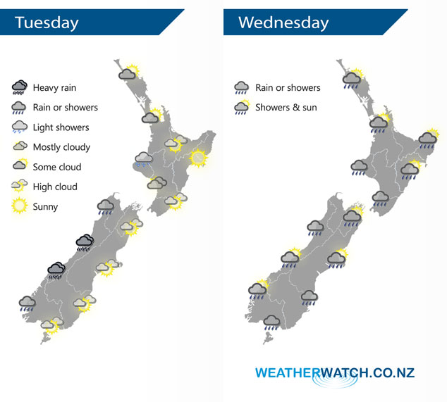
A northwesterly airflow picks up today with a front moving onto the South Island from the west this afternoon / evening. An area of low pressure gradually draws in a southerly airflow over the South Island on Wednesday.
Mainly dry today for most of the North Island however northern Taranaki and Kapiti may see a light shower or two. The West Coast of the South Island sees rain, becoming heavy from afternoon then easing overnight. A mainly dry day in the east with some high cloud, Southland and Otago may see a spot of rain at times from afternoon otherwise mainly dry.
Most regions around New Zealand can expect some rain or showers for a time on Wednesday but nothing is overly severe or terribly cold. Conditions will start to cool down a little for the eastern South Island as a southerly airflow slowly makes its way northwards over the South Island during the day. The West Coast of the South Island gets some good weather from afternoon after morning showers clear.
By Weather Analyst Aaron Wilkinson – WeatherWatch.co.nz
Latest Video

Matariki, the long weekend + the outlook for next week
Wet weather and cloud continues along the eastern side of the country with the heaviest rain now moving into northern…
Related Articles
Matariki, the long weekend + the outlook for next week
Wet weather and cloud continues along the eastern side of the country with the heaviest rain now moving into northern…

More eastern rain, but a drier long weekend coming
Rain continues today along the eastern South Island and lower North Island, coming in from the east with heavy falls….

More heavy rain, snow – but large dry areas, especially as we go into the long weekend
Heavy rain will continue for parts of Canterbury and Marlborough over the next day or two and it will gradually…

