InfoGraphic: The Big Picture for Tuesday / Wednesday
6/05/2019 7:00pm

> From the WeatherWatch archives
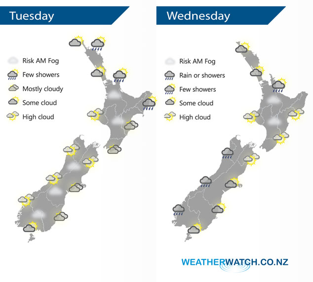
A large anticyclone brings mainly settled conditions to New Zealand today, plenty of high cloud about though and areas of low cloud / fog morning and night. A northerly airflow lies over New Zealand on Wednesday ahead of a front which slowly makes it’s way onto the western side of the South Island. A large high gets shunted to the east.
Cloud a little more frequent over the North Island today especially in the east, a light shower or two may brush Gisborne, Coromandel, Great Barrier Island and eastern Northland at times. Low cloud or fog possible once again morning and night for inland areas. The South Island has cloudy areas in the east, high cloud elsewhere with a risk of fog once again in the morning for inland areas.
A mix of sun and cloud for much of the North Island on Wednesday, some morning fog possible once again for inland areas. A light shower or two may affect Bay Of Plenty, perhaps extending into the Waikato for a time in the evening. Rain or showers moving onto the South Islands West Coast, morning mid level cloud breaks to sunny areas and high cloud out east. A few spots of rain possible about Southland and Otago in the afternoon.
By Weather Analyst Aaron Wilkinson – WeatherWatch.co.nz
Latest Video

Frosts, clearer skies coming – severe weather possible this weekend
High pressure lies south of NZ today and that placement encourages a colder south-east wind into the North Island bringing…
Related Articles
Frosts, clearer skies coming – severe weather possible this weekend
High pressure lies south of NZ today and that placement encourages a colder south-east wind into the North Island bringing…

NZ: 8 Day outlook as gales & rain ease, high pressure builds
Damaging wind gusts and heavy rain will continue to affect some parts of the North Island and brushing Marlborough today…

Pockets of hit & miss heavy rain, snow moves northwards
Low pressure continues to slowly move across the upper North Island and for some that will bring the sun out,…

