InfoGraphic: The Big Picture for Tuesday / Wednesday
4/03/2019 6:00pm

> From the WeatherWatch archives
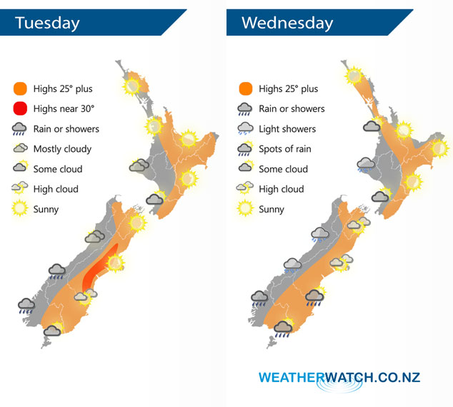
An anticyclone covers most of New Zealand today, a west to northwesterly airflow lies over the South Island. A ridge covers the North Island on Wednesday, northwesterlies further south.
Mostly sunny for a majority of the North Island today, expect some cloud in the west Taranki southwards however, perhaps breaking to some sun this afternoon. Mostly cloudy for the West Coast of the South Island, rain or showers for Fiordland. Mostly sunny for Nelson, Marlborough and Canterbury. Otago and Southland may see some cloud.
Cloudy areas for the western North Island on Wednesday, mainly western Waikato southwards, there may even be a light shower or two especially morning. Mostly sunny elsewhere. Quite cloudy for the South Islands West Coast with a few light showers, drier in the east with some sun however there could be a few early spots of rain for Southland and Otago then clearing away.
By Weather Analyst Aaron Wilkinson – WeatherWatch.co.nz
Latest Video

NZ: 8 Day outlook as gales & rain ease, high pressure builds
Damaging wind gusts and heavy rain will continue to affect some parts of the North Island and brushing Marlborough today…
Related Articles
NZ: 8 Day outlook as gales & rain ease, high pressure builds
Damaging wind gusts and heavy rain will continue to affect some parts of the North Island and brushing Marlborough today…

Pockets of hit & miss heavy rain, snow moves northwards
Low pressure continues to slowly move across the upper North Island and for some that will bring the sun out,…

Slow go for northern low & southern cold
For the next few days low pressure will crawl over the upper North Island, driving in rain as far south…

