InfoGraphic: The Big Picture for Tuesday / Wednesday
12/02/2018 6:00pm

> From the WeatherWatch archives
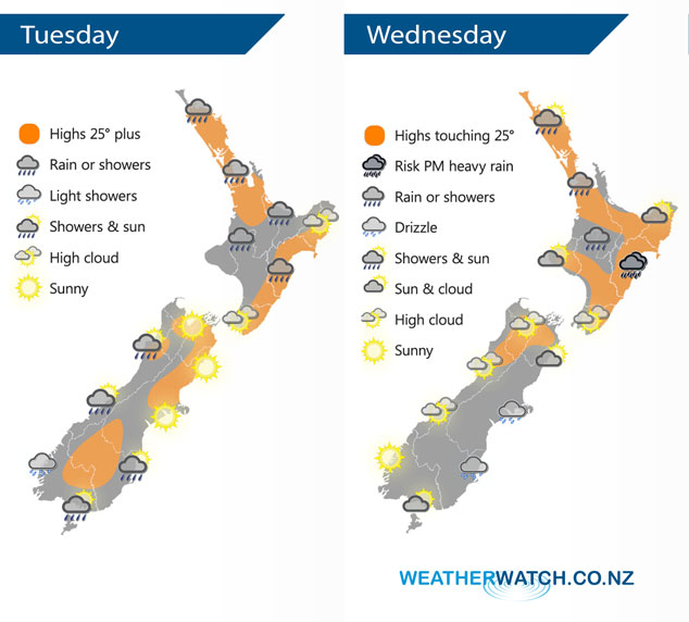
A front lingers over the North Island today in a very humid northerly quarter airflow. Meanwhile the South Island has generally more settled weather with dry sunny conditions in the east and the odd clearing shower / drizzle patch out west. A similar setup continues on Wednesday however for the South Island this time its cloudier in the east and sunnier out west.
A few showers today for many North Island regions, still the chance of a heavy fall or two otherwise conditions may be quite patchy with long dry spells.
Sunny for the east of the South Island, a few showers move into Southland and Otago during this afternoon and evening as a southwest flick moves through. Morning drizzle or showers clear the West Coast then sunny spells increase.
Another day of showers for the upper North Island for Wednesday, still a heavy fall or two possible mainly afternoon then clearing away in the evening. The east coast is mainly dry to start then cloud builds in the afternoon with showers developing, especially about Hawkes Bay and perhaps Gisborne where there may be a few downpours then clearing later on.
A mainly sunny day for the South Island’s West Coast after any morning cloud breaks away, some drizzle at times Banks Peninsula southwards in the east. Sunnier further north in the east however some cloud and a risk of drizzle does push northwards in the evening.
By Weather Analyst Aaron Wilkinson – WeatherWatch.co.nz
Latest Video

Slow go for northern low & southern cold
For the next few days low pressure will crawl over the upper North Island, driving in rain as far south…
Related Articles
Slow go for northern low & southern cold
For the next few days low pressure will crawl over the upper North Island, driving in rain as far south…

Slow moving low to track over northern NZ
A low pressure zone will slowly cross the North Island over the coming days, bringing hit and miss pockets of…

NI low pressure, SI polar change
Low pressure will move over the upper North Island this week, bringing hit and miss pockets of heavier rain into…

