
> From the WeatherWatch archives
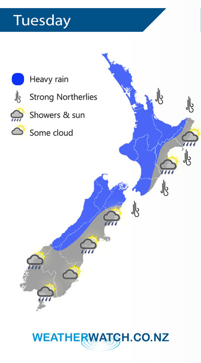
A front passes over the North Island on Tuesday moving in a west to east fashion clearing off to the east by late afternoon. A west to southwesterly airflow lies over the South Island.
Morning rain for the western North Island may be heavy on Tuesday then easing to showers and sunny spells from afternoon, dry at first in the east then some rain passes over from the west in the afternoon, clearing evening.
Early heavy rain for the South Island’s West Coast, Nelson and Marlborough then easing. Cloudy areas for elsewhere in the South Island with the odd shower about especially for Southland and Fiordland, just the risk of a shower for Canterbury.
By Weather Analyst Aaron Wilkinson – WeatherWatch.co.nz
Comments
Latest Video

Cold fronts continue, wind & rain for some Fri/Sat
Wet weather is moving over the North Island today, while the South Island has drier skies – ahead of another…
Related Articles
Cold fronts continue, wind & rain for some Fri/Sat
Wet weather is moving over the North Island today, while the South Island has drier skies – ahead of another…

Cold fronts vs high pressure
A cold front is moving up NZ today and into Tuesday, but will fall apart as it heads north and…

Wintry change coming for SI and lower NI
Some wet weather, along with a drop in temperatures, will move into the lower South Island later on Sunday and…


Guest on 15/07/2019 4:23am
so there will be heavy rain you said that yesterday in an area marked in blue and there was none unless you call 12.5 mils heavy rain
WW Forecast Team on 15/07/2019 4:42am
Hi there
Which map are you reffering too? Our Infographics don’t come out on Sunday.
Auckland had 13mm between 11am and midday yesterday which is a reasonable period of rain in a fairly short time. Heavy rain is defined as being more then around 8mm per hour so that works out to be about right.
Cheers
WW