
> From the WeatherWatch archives
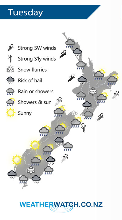
A trough pushes onto the North Island on Tuesday morning bringing very unsettled weather and strong cold southwesterly winds. Cold southwesterlies lie over the South Island also.
Quite unsettled over the North Island on Tuesday as a trough pushes northwards bringing very cold temperatures, heavy rain for a time and some hail. Snow lowers to 400m about the Central Plateau.
Showers about Canterbury (possibly heavy with hail and snow flurries to 300m) becoming quite coastal during the morning and clearing away from inland areas. The West Coast, Nelson and Marlborough sees morning showers clear then sunny areas increase. Showers about Southland and Otago may be heavy early in the morning with hail then easing, snow flurries to 200m at first then lifting during the day.
By Weather Analyst Aaron Wilkinson – WeatherWatch.co.nz
Latest Video

ClimateWatch: JULY outlook & what El Niño means for NZ
El Niño is officially here and still getting stronger in the months ahead, but it’s harder to notice its effects…
Related Articles
ClimateWatch: JULY outlook & what El Niño means for NZ
El Niño is officially here and still getting stronger in the months ahead, but it’s harder to notice its effects…

Low pressure heading to NZ this weekend & into next week
Many regions have settled weather at the moment with frosts as far north as Auckland this morning, but still some…

Colder nights/mornings, polar change coming Sun/Mon
The nights and mornings ahead will be colder in a number of regions – but an even colder change is…

