InfoGraphic: The Big Picture for Thursday / Friday
2/10/2019 7:04pm

> From the WeatherWatch archives
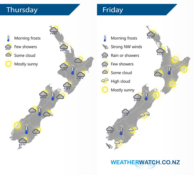
A moderate southwesterly airflow lies over the country today, tilting more west to northwest on Friday and gradually strengthening. A cold front hits the lower South Island overnight Friday.
Cloudy areas and the odd shower for the western North Island today, the Bay Of Plenty and perhaps Waikato has a mainly sunny morning then cloud increases. Dry with some sun about Hawkes Bay and Gisborne, a shower or two may move in by late afternoon. Mostly sunny about South Westland after morning high cloud clears, a shower or two likely north of about Greymouth during the day. Cloudy areas for Nelson, perhaps a shower or two also. Canterbury sees any morning cloud break to sunny areas, the odd shower on Banks Peninsula clears in the evening. Cloudy areas about Southland with a shower or two, morning cloud then afternoon sunny spells for Otago.
Some cloud for the western North Island again on Friday, risk of a shower for Northland and Auckland. Mainly sunny for eastern regions. The West Coast of the South Island is fairly cloudy with a few showers, rain moves into South Westland during the afternoon then becomes heavy. Warm and dry in the east with developing high cloud.
By Weather Analyst Aaron Wilkinson – WeatherWatch.co.nz
Latest Video

NZ: 8 Day outlook as gales & rain ease, high pressure builds
Damaging wind gusts and heavy rain will continue to affect some parts of the North Island and brushing Marlborough today…
Related Articles
NZ: 8 Day outlook as gales & rain ease, high pressure builds
Damaging wind gusts and heavy rain will continue to affect some parts of the North Island and brushing Marlborough today…

Pockets of hit & miss heavy rain, snow moves northwards
Low pressure continues to slowly move across the upper North Island and for some that will bring the sun out,…

Slow go for northern low & southern cold
For the next few days low pressure will crawl over the upper North Island, driving in rain as far south…

