InfoGraphic: The Big Picture for Thursday / Friday
25/09/2019 7:00pm

> From the WeatherWatch archives
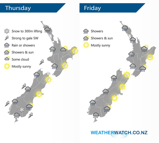
A west to southwesterly airflow lies over the country on Thursday and Friday.
Expect showers for much of the western North Island today, long dry periods for the Bay Of Plenty. Mostly sunny conditions for the east coast. The West Coast of the South Island, Southland and Otago has rain or showers, snow to 400m or maybe even 300m in the morning with a risk of hail then lifting during the day. Mostly sunny for Canterbury and Marlborough, a few evening showers move into Canterbury as westerlies tend southwest.
Showers for the western North Island again on Friday, showers develop in the morning about Wairarapa then a few push northwards into Hawkes Bay and Gisborne in the afternoon. A generally showery day for Southland and along the West Coast of the South Island, Otago has morning cloud with the risk of a shower then sunny spells develop.
By Weather Analyst Aaron Wilkinson – WeatherWatch.co.nz
Latest Video

Matariki, the long weekend + the outlook for next week
Wet weather and cloud continues along the eastern side of the country with the heaviest rain now moving into northern…
Related Articles
Matariki, the long weekend + the outlook for next week
Wet weather and cloud continues along the eastern side of the country with the heaviest rain now moving into northern…

More eastern rain, but a drier long weekend coming
Rain continues today along the eastern South Island and lower North Island, coming in from the east with heavy falls….

More heavy rain, snow – but large dry areas, especially as we go into the long weekend
Heavy rain will continue for parts of Canterbury and Marlborough over the next day or two and it will gradually…

