InfoGraphic: The Big Picture for Thursday / Friday
7/08/2019 7:00pm

> From the WeatherWatch archives
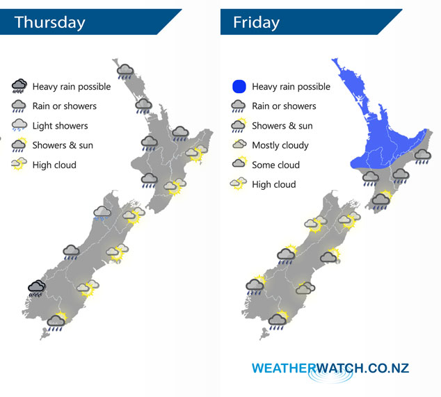
A northwesterly airflow lies over New Zealand today. An area of low pressure brings rain to the upper North Island on Friday with heavy falls possible, more settled further south however there are still a few showers about.
Areas of rain or showers for western regions today, rain may be heavy about Fiordland. Rain may also become heavy for the western North Island overnight Taranaki northwards. Mainly dry weather in the east with some high cloud and warm temperatures. Spots of rain possible about Southland from afternoon.
Areas of rain may be heavy about the upper North Island on Friday, especially early morning then again late afternoon / evening. The odd shower for the West Coast of the South Island, mostly sunny with some high cloud about Nelson / Marlborough. Canterbury has some morning sun then cloud builds from afternoon with southeasterly winds. Cloud and the risk of some drizzle developing in the morning about the far south.
By Weather Analyst Aaron Wilkinson – WeatherWatch.co.nz
Latest Video

NZ: 8 Day outlook as gales & rain ease, high pressure builds
Damaging wind gusts and heavy rain will continue to affect some parts of the North Island and brushing Marlborough today…
Related Articles
NZ: 8 Day outlook as gales & rain ease, high pressure builds
Damaging wind gusts and heavy rain will continue to affect some parts of the North Island and brushing Marlborough today…

Pockets of hit & miss heavy rain, snow moves northwards
Low pressure continues to slowly move across the upper North Island and for some that will bring the sun out,…

Slow go for northern low & southern cold
For the next few days low pressure will crawl over the upper North Island, driving in rain as far south…

