InfoGraphic: The Big Picture for Thursday / Friday
19/06/2019 7:00pm

> From the WeatherWatch archives
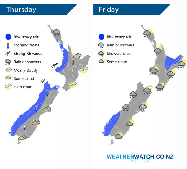
An anticyclone to the east and a low pressure system to the west directs a northerly airflow over New Zealand today, a front pushes into western areas during the day. This front passes off to the east of New Zealand on Friday morning, some morning rain in the east then becoming mostly sunny. Rain or showers in the west, easing from afternoon for the western North Island.
Dry for eastern New Zealand today but expect some high cloud, a touch of frost possible for inland areas. Cloudy in the west with rain or showers about South Westland and Northland, gradually pushing into other western regions by evening and possibly becoming heavy.
Early rain for the western North Island, easing to showers in the morning and some sun breaks through by midday. Morning rain about Bay Of Plenty (especially in the east) may be heavy. Some morning rain for the eastern North Island then afternoon sun. Rain or showers for the West Coast, rain heavy at times for Fiordland mainly morning then again at night. Cloud or showers for the eastern South Island breaks to mostly sunny weather during the morning.
By Weather Analyst Aaron Wilkinson – WeatherWatch.co.nz
Latest Video

Cold weekend, frosts return with high pressure, then a low late next week
The subantarctic airflow spreads over NZ today/tonight and into Saturday, dropping temperatures nationwide. Snow flurries are possible today to lower…
Related Articles
Cold weekend, frosts return with high pressure, then a low late next week
The subantarctic airflow spreads over NZ today/tonight and into Saturday, dropping temperatures nationwide. Snow flurries are possible today to lower…

Wintry burst of weather: Snow, squally showers then sunshine & frosts
A polar change (another one!) arrives on Friday for the South Island and goes nationwide on Saturday, leaving NZ under…

Antarctic southerly for parts of NZ Fri & Sat
For the first time this year a southerly from off Antarctica is heading towards the South Island, followed by more…

