InfoGraphic: The Big Picture for Thursday / Friday
19/09/2018 7:00pm

> From the WeatherWatch archives
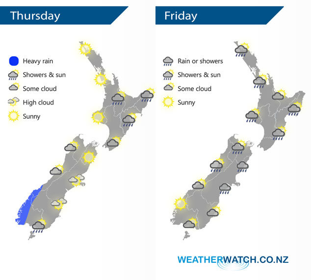
A slack pressure gradient may bring isolated showers late afternoon / evening for some northeastern parts of the North Island today (mainly inland), showers clear away in the east. Mainly dry for a majority of the South Island with a front moving onto the lower South Island during the day. This front pushes northwards over the South Island on Friday morning then the North Island in the afternoon / evening.
Mostly sunny for the upper North Island today, isolated showers may develop late afternoon / evening about inland Bay Of Plenty and the ranges of Hawkes Bay / Gisborne. Light winds tend southwest in the afternoon. Showers in the east clear with some sun breaking through from afternoon. Some heavy rain moves into Fiordland from afternoon, cloud thickens further north in the west. Mostly sunny in the east with increasing high cloud, a few showers may move into Southland late afternoon / evening.
Dry for most of the North Island on Friday then showers develop late afternoon in the west and during the evening in the east. Showers develop about the upper South Island in the afternoon, some may be heavy for inland areas then clearing away later in the evening / overnight. Southland and Otago see any early showers mostly clearing then expect some afternoon sun.
By Weather Analyst Aaron Wilkinson – WeatherWatch.co.nz
Latest Video

Matariki, the long weekend + the outlook for next week
Wet weather and cloud continues along the eastern side of the country with the heaviest rain now moving into northern…
Related Articles
Matariki, the long weekend + the outlook for next week
Wet weather and cloud continues along the eastern side of the country with the heaviest rain now moving into northern…

More eastern rain, but a drier long weekend coming
Rain continues today along the eastern South Island and lower North Island, coming in from the east with heavy falls….

More heavy rain, snow – but large dry areas, especially as we go into the long weekend
Heavy rain will continue for parts of Canterbury and Marlborough over the next day or two and it will gradually…

