InfoGraphic: The Big Picture for Thursday / Friday
23/05/2018 7:00pm

> From the WeatherWatch archives
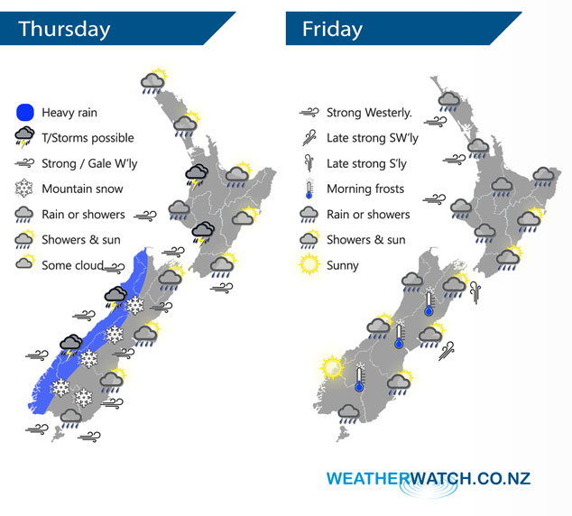
A front races northwards over the South Island this morning then pushes northwards over the North Island this afternoon / evening, all in a strong westerly quarter airflow. A large low pressure system is centred to the east of New Zealand on Friday slowly rotating a cold southwesterly airflow over the country bringing unsettled weather to most regions.
A front brings heavy rain to the West Coast of the South Island today, reaching the western side of the North Island in the afternoon. This front may bring thunderstorms also. Generally dry for eastern regions although as a front passes over spots of rain will spread from the west. Winds strong from the west for much of the South Island and lower North Island.
Snow to 500m about the mountainous parts of the South Island south of Buller, perhaps 400m at a push for parts of Fiordland / Southland. As the flow will be westerly snow will be coming in from the west so the further east one goes into the foothills of Canterbury for example it will become drier and snow levels will lift.
Areas of rain or showers for most of the North Island on Friday, there may be a few heavy falls with thunderstorms and hail in the west at times, mainly south of Taranaki in the morning then further northwards in the afternoon. For the West Coast of the South Island any early showers clear then conditions becoming mainly sunny. The odd shower about coastal Southland spreads northwards during the afternoon and evening into parts of Otago and Canterbury.
By Weather Analyst Aaron Wilkinson – WeatherWatch.co.nz
Latest Video

NZ: 8 Day outlook as gales & rain ease, high pressure builds
Damaging wind gusts and heavy rain will continue to affect some parts of the North Island and brushing Marlborough today…
Related Articles
NZ: 8 Day outlook as gales & rain ease, high pressure builds
Damaging wind gusts and heavy rain will continue to affect some parts of the North Island and brushing Marlborough today…

Pockets of hit & miss heavy rain, snow moves northwards
Low pressure continues to slowly move across the upper North Island and for some that will bring the sun out,…

Slow go for northern low & southern cold
For the next few days low pressure will crawl over the upper North Island, driving in rain as far south…

