InfoGraphic: The Big Picture for Thursday / Friday
18/04/2018 7:00pm

> From the WeatherWatch archives
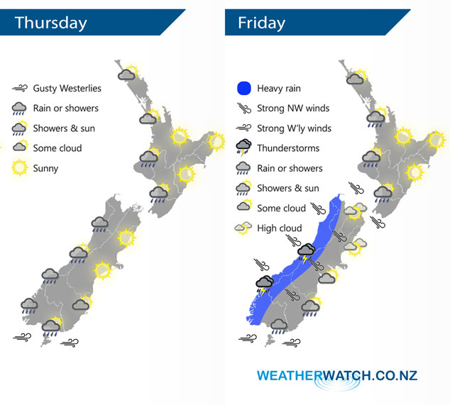
A west to southwesterly airflow flows over New Zealand today with a cold front pushing onto the lower South Island overnight. This front pushes northwards on Friday however weakens quickly from afternoon then another cold front moves onto the lower South Island later in the evening.
Showers for western New Zealand today although fairly dry north of Taranaki, still could be a rogue shower or two however.
Eastern regions look to have a great day with temperatures getting into the high teens or early twenties.
Rain for the west of the South Island on Friday morning may be heavy at times with a chance of thunderstorms then easing from afternoon. Northwesterly winds about the inner South Island will be brisk or strong at times, perhaps gusting to gale force in exposed areas. Overall a generally dry day in the east and wet in the west although the western North Island will see areas of dry at times.
By Weather Analyst Aaron Wilkinson – WeatherWatch.co.nz
Latest Video

Wintry weather coming: Snow, rain, wind & sunshine
A cold front is moving into NZ from Friday to Sunday with low pressure developing west of NZ and then…
Related Articles
Wintry weather coming: Snow, rain, wind & sunshine
A cold front is moving into NZ from Friday to Sunday with low pressure developing west of NZ and then…

ClimateWatch: JULY outlook & what El Niño means for NZ
El Niño is officially here and still getting stronger in the months ahead, but it’s harder to notice its effects…

Low pressure heading to NZ this weekend & into next week
Many regions have settled weather at the moment with frosts as far north as Auckland this morning, but still some…

