InfoGraphic: The Big Picture for Saturday / Sunday
14/12/2018 6:00pm

> From the WeatherWatch archives
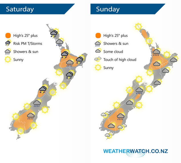
Anticyclonic conditions for most of New Zealand on Saturday mean the weather is starting to become quite settled and areas of sun are finally breaking through for many. However, some residual surface moisture and afternoon heating plus relatively cold air aloft leads to a chance of thunderstorms in the afternoon for some inland areas. A large high brings mainly settled weather on Sunday.
A few isolated showers about the upper North Island on Saturday, becoming heavy with some thunder in the afternoon for inland areas then easing later in the evening. The lower North Island has a mostly sunny day, however, cloud builds about the ranges from Wairarapa through to Gisborne in the afternoon bringing showers. Showers possibly heavy with thunderstorms then easing later in the evening. Mostly sunny for the South Island however a few isolated showers crop up about inland areas in the afternoon, a chance of thunder for Buller.
As in the situation statement above Sunday’s weather is dominated by a large anticyclone, this means mainly sunny and settled weather. However, still the slight risk of a sneaky isolated shower late afternoon or evening about some inland areas, mainly forming on hills / ranges.
By Weather Analyst Aaron Wilkinson – WeatherWatch.co.nz
Latest Video

Colder nights/mornings, polar change coming Sun/Mon
The nights and mornings ahead will be colder in a number of regions – but an even colder change is…
Related Articles
Colder nights/mornings, polar change coming Sun/Mon
The nights and mornings ahead will be colder in a number of regions – but an even colder change is…

Frosts, clearer skies coming – severe weather possible this weekend
High pressure lies south of NZ today and that placement encourages a colder south-east wind into the North Island bringing…

NZ: 8 Day outlook as gales & rain ease, high pressure builds
Damaging wind gusts and heavy rain will continue to affect some parts of the North Island and brushing Marlborough today…

