InfoGraphic: The Big Picture for Saturday / Sunday
24/08/2018 3:17am

> From the WeatherWatch archives
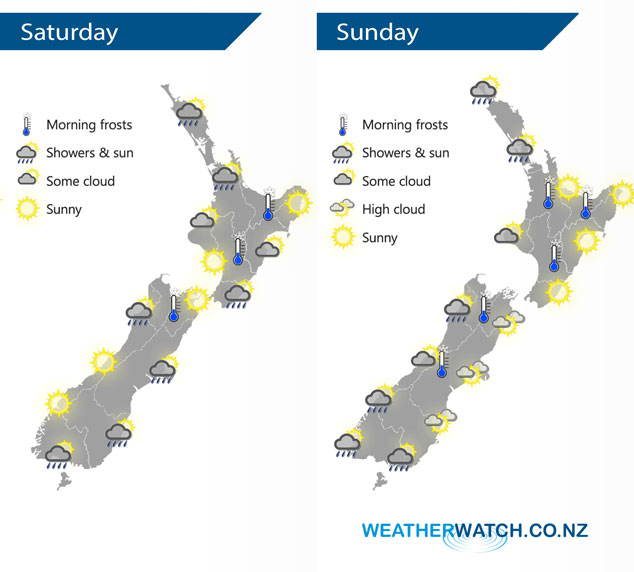
A southwesterly airflow lies over New Zealand on Saturday, a weak front within this flow quickly moves northwards over the South Island in the morning then the North Island from afternoon. A ridge of high pressure sits over the North Island on Sunday, a westerly quarter airflow lies over the South Island.
A shower or two for the western North Island on Saturday, mainly Waikato through to Northland. Drier elsewhere however a shower or two may move into Wairarapa in the afternoon along the east coast and perhaps further north in the evening. Early morning showers clear Southland / Otago then sunny areas increase, only the chance of brief shower moving through Canterbury around midday. Mostly sunny about Nelson / Marlborough and the West Coast, Buller however sees a shower or two from afternoon.
A mostly sunny day for the North Island on Sunday, a shower or two possible for Auckland and Northland, mainly in the morning. A shower or two possible along the West Coast of the South Island, a spot or two of rain possible about Southland also. Along the east coast and up through to Nelson conditions are mainly sunny with a touch of high cloud.
By Weather Analyst Aaron Wilkinson – WeatherWatch.co.nz
Latest Video

NZ: 8 Day outlook as gales & rain ease, high pressure builds
Damaging wind gusts and heavy rain will continue to affect some parts of the North Island and brushing Marlborough today…
Related Articles
NZ: 8 Day outlook as gales & rain ease, high pressure builds
Damaging wind gusts and heavy rain will continue to affect some parts of the North Island and brushing Marlborough today…

Pockets of hit & miss heavy rain, snow moves northwards
Low pressure continues to slowly move across the upper North Island and for some that will bring the sun out,…

Slow go for northern low & southern cold
For the next few days low pressure will crawl over the upper North Island, driving in rain as far south…

