InfoGraphic: The Big Picture for Saturday / Sunday
3/08/2018 4:00am

> From the WeatherWatch archives
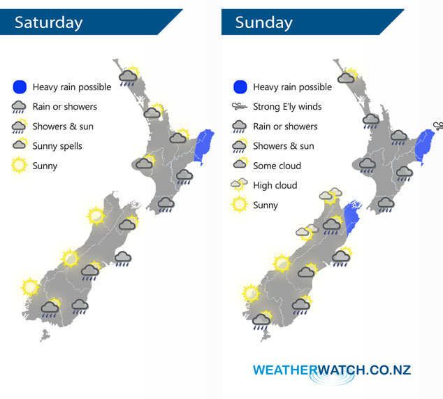
A large high is centred off to the southeast of the South Island on Saturday and Sunday directing in an easterly quarter airflow over the country. Within this airflow is an occluded front which affects eastern parts of both islands.
Mostly sunny for the western North Island on Saturday after any morning cloud or fog breaks away, winds light from the southerly quarter. Northland could see a shower or two at times during the day, mainly in the west. Rain for the east coast with the odd heavy fall possible, especially about Gisborne. Sunny for the South Island’s West Coast, areas of cloud in the east may bring a shower or two. Rain moves into Marlborough during the afternoon then Canterbury later in the evening.
The general outlook for Sunday is a drier day in the west and wet in the east, some eastern regions could see a heavy fall or two at times also. The latest indications are that Auckland will stay mainly dry however a shower or two could spread from the east for a brief time in the evening.
By Weather Analyst Aaron Wilkinson – WeatherWatch.co.nz
Comments
Latest Video

NZ: 8 Day outlook as gales & rain ease, high pressure builds
Damaging wind gusts and heavy rain will continue to affect some parts of the North Island and brushing Marlborough today…
Related Articles
NZ: 8 Day outlook as gales & rain ease, high pressure builds
Damaging wind gusts and heavy rain will continue to affect some parts of the North Island and brushing Marlborough today…

Pockets of hit & miss heavy rain, snow moves northwards
Low pressure continues to slowly move across the upper North Island and for some that will bring the sun out,…

Slow go for northern low & southern cold
For the next few days low pressure will crawl over the upper North Island, driving in rain as far south…


LM on 3/08/2018 3:25am
Why is there a shower icon over the far south for the weekend especially when there are no showers/rain forecast??
WW Forecast Team on 3/08/2018 5:37am
Hi LM, fair comment. Southland looks to be one of the best places to be this weekend! 🙂 There may be some risk further to the east of a shower at some point in the weekend, with a 20% chance, which jumps to 70% further on the east coast but moreso towards coastal Otago. But you’re right a sun/cloud icon or a sun only one would be better. Have a good weekend in the best weather part of the country this weekend!
Cheers
WW Weekend Team