InfoGraphic: The Big Picture for Saturday / Sunday
13/07/2018 6:34pm

> From the WeatherWatch archives
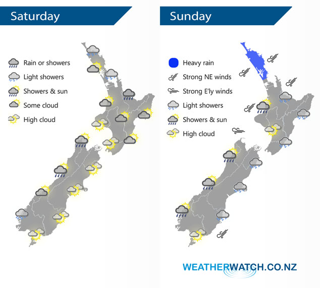
An east to northeasterly airflow gradually increases over New Zealand Saturday as a large low pressure system churns away in the Tasman Sea. A gusty northeasterly airflow covers the country on Sunday with a front just to the west and also covering Northland.
A few showers or drizzle patches for eastern parts of the North Island from Northland down through to the Bay Of Plenty, areas of sun too especially in the west. For the lower North Island conditions are a bit brighter. The West Coast of the South Island may see a morning shower or two then breaking to sunny areas and some high cloud in the afternoon. Sunny areas and some high cloud for most eastern areas.
Mostly cloudy for much of the North Island on Sunday with the odd light shower or drizzle patch, just north of Auckland expect a band of rain with heavy falls at times. Winds will be brisk to strong from the northeast also. For the South Island it’s a mainly cloudy day in the east, the odd light shower or drizzle patch possible. Along the West Coast expect some high cloud then showers or rain late afternoon / evening.
By Weather Analyst Aaron Wilkinson – WeatherWatch.co.nz
Latest Video

Matariki, the long weekend + the outlook for next week
Wet weather and cloud continues along the eastern side of the country with the heaviest rain now moving into northern…
Related Articles
Matariki, the long weekend + the outlook for next week
Wet weather and cloud continues along the eastern side of the country with the heaviest rain now moving into northern…

More eastern rain, but a drier long weekend coming
Rain continues today along the eastern South Island and lower North Island, coming in from the east with heavy falls….

More heavy rain, snow – but large dry areas, especially as we go into the long weekend
Heavy rain will continue for parts of Canterbury and Marlborough over the next day or two and it will gradually…

