InfoGraphic: The Big Picture for Saturday / Sunday
11/05/2018 3:00am

> From the WeatherWatch archives
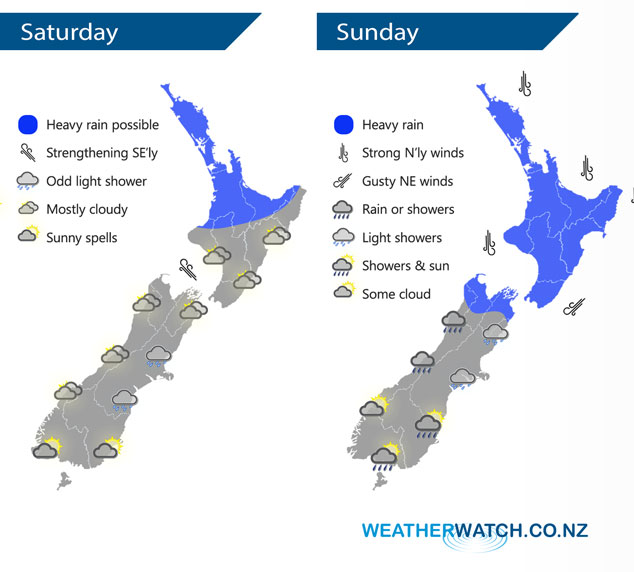
A southerly quarter airflow swings around to the northeast in the afternoon over New Zealand on Saturday, a un-organised front over the upper North Island strengthens from afternoon bringing heavy rain potential. A northerly quarter airflow lies over the country on Sunday.
Rain will have eased by Saturday morning for the upper North Island then from afternoon a front becomes more organised pushing down from the north lifting the risk of heavy rain once again, the Waikato and Bay Of Plenty don’t see this heavy rain potential till evening. Quite cloudy for the rest of New Zealand with the chance of a few light showers about, especially Canterbury in the morning.
Rain for the northern half of New Zealand may be heavy at times during Sunday, it won’t be heavy all day long. The lower half of the South Island is mainly dry with showers south of about Timaru only possible later in the day.
By Weather Analyst Aaron Wilkinson – WeatherWatch.co.nz
Latest Video

Wintry weather coming: Snow, rain, wind & sunshine
A cold front is moving into NZ from Friday to Sunday with low pressure developing west of NZ and then…
Related Articles
Wintry weather coming: Snow, rain, wind & sunshine
A cold front is moving into NZ from Friday to Sunday with low pressure developing west of NZ and then…

ClimateWatch: JULY outlook & what El Niño means for NZ
El Niño is officially here and still getting stronger in the months ahead, but it’s harder to notice its effects…

Low pressure heading to NZ this weekend & into next week
Many regions have settled weather at the moment with frosts as far north as Auckland this morning, but still some…

