InfoGraphic: The Big Picture for Monday / Tuesday
15/09/2019 7:25pm

> From the WeatherWatch archives
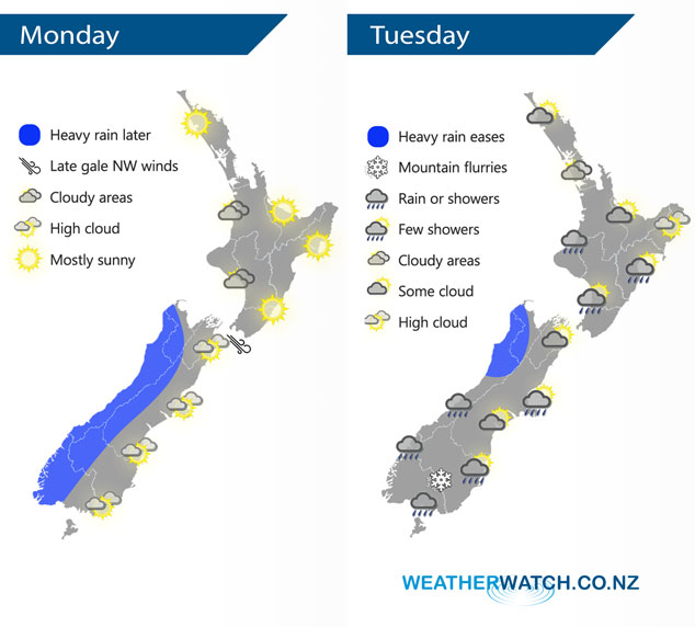
A northwesterly airflow strengthens over New Zealand today with a cold front moving onto the lower South Island this evening reaching Cook Strait overnight. This cold front continues northwards over the North Island on Tuesday weakening as it goes, a cold southwest airflow lies over the South Island.
Mostly sunny for a fair amount of the North Island today however expect cloudy areas for some western areas, perhaps the risk of a brief shower or two at times about Taranaki through to Kapiti. Rain becomes heavy this evening for the West Coast of the South Island at which point there may be a rumble of thunder or two. High cloud out east with rain / showers spreading into Southland and Otago this evening with a gusty westerly change. Northwest winds rise to gale later this evening about Cook Strait and also perhaps about some inland parts of Canterbury.
A band of rain / showers moves northwards over the North Island slowly during Tuesday, not reaching Auckland and Northland till the evening / overnight. Early heavy rain eases about the northwestern corner of the South Island, expect showers for most other South Island regions although Canterbury and Marlborough are mainly dry. Canterbury could see a shower or two from afternoon Banks Peninsula northwards. A few sleety showers are to be expected about Southland with a few snow flurries to 400 or perhaps even 300m at times in a cold westerly airflow.
By Weather Analyst Aaron Wilkinson – WeatherWatch.co.nz
Latest Video

NZ: 8 Day outlook as gales & rain ease, high pressure builds
Damaging wind gusts and heavy rain will continue to affect some parts of the North Island and brushing Marlborough today…
Related Articles
NZ: 8 Day outlook as gales & rain ease, high pressure builds
Damaging wind gusts and heavy rain will continue to affect some parts of the North Island and brushing Marlborough today…

Pockets of hit & miss heavy rain, snow moves northwards
Low pressure continues to slowly move across the upper North Island and for some that will bring the sun out,…

Slow go for northern low & southern cold
For the next few days low pressure will crawl over the upper North Island, driving in rain as far south…

