InfoGraphic: The Big Picture for Monday / Tuesday
4/08/2019 7:00pm

> From the WeatherWatch archives
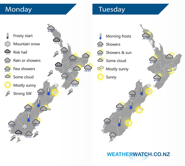
A cold southwesterly airflow lies over New Zealand today, easing and tending a little more westerly on Tuesday.
Showers for the upper / western North Island may be heavy at times with hail / thunder this morning then gradually easing, cold southwesterlies. Sunny spells in the east with the odd shower skirting past a few coastal fringe areas like Mahia Peninsula. Showers for the west and south of the South Island, perhaps some hail this morning about the far south then easing. Snow flurries to low levels this morning about Southland and Otago (100 to 200m) then lifting to 400m this afternoon. Mainly dry in Canterbury however some afternoon cloud brings the low risk of a shower. Nelson and Marlborough are mainly sunny.
A few showers for most western regions on Tuesday, sunnier out east with a touch of high cloud possible for the eastern North Island. Southland is mainly cloudy with the odd shower.
By Weather Analyst Aaron Wilkinson – WeatherWatch.co.nz
Latest Video

Frosts, clearer skies coming – severe weather possible this weekend
High pressure lies south of NZ today and that placement encourages a colder south-east wind into the North Island bringing…
Related Articles
Frosts, clearer skies coming – severe weather possible this weekend
High pressure lies south of NZ today and that placement encourages a colder south-east wind into the North Island bringing…

NZ: 8 Day outlook as gales & rain ease, high pressure builds
Damaging wind gusts and heavy rain will continue to affect some parts of the North Island and brushing Marlborough today…

Pockets of hit & miss heavy rain, snow moves northwards
Low pressure continues to slowly move across the upper North Island and for some that will bring the sun out,…

