InfoGraphic: The Big Picture for Monday / Tuesday
21/07/2019 7:00pm

> From the WeatherWatch archives
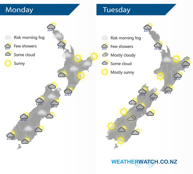
A slack pressure gradient lies over New Zealand today bringing light winds, mainly settled weather can be expected although not always sunny. Similar again on Tuesday although there is a little more shower activity about especially for the eastern North Island.
Mainly sunny for the eastern North Island today, a few showers possible Auckland northwards. There is a risk of some fog this morning about most upper North Island areas especially inland away from the coast. A light shower or two for the western South Island today, mainly from afternoon. Morning low cloud or fog in the east breaks to sunny areas. A light morning shower or two for Marlborough clears.
A shower or two continues to affect Northland and Auckland north of the CBD on Tuesday, expect long dry periods too. Cloud builds with showers moving into eastern areas, in the middle from Bay Of Plenty through to Taranaki and Manawatu expect mostly sunny conditions after any morning fog clears. A patchy light shower or two for the upper South Island, also perhaps about inland Canterbury at times. Conditions are mainly sunny about South Westland, Southland and perhaps parts of Otago especially inland.
By Weather Analyst Aaron Wilkinson – WeatherWatch.co.nz
Comments
Latest Video

Matariki, the long weekend + the outlook for next week
Wet weather and cloud continues along the eastern side of the country with the heaviest rain now moving into northern…
Related Articles
Matariki, the long weekend + the outlook for next week
Wet weather and cloud continues along the eastern side of the country with the heaviest rain now moving into northern…

More eastern rain, but a drier long weekend coming
Rain continues today along the eastern South Island and lower North Island, coming in from the east with heavy falls….

More heavy rain, snow – but large dry areas, especially as we go into the long weekend
Heavy rain will continue for parts of Canterbury and Marlborough over the next day or two and it will gradually…


Grace on 21/07/2019 8:34pm
Hi! What’s the outlook looking like for Ruapehu on Thursday and Friday? Thanks!
WW Forecast Team on 21/07/2019 8:40pm
Morning Grace,
At this stage both Thursday and Friday look fairly good around the mountain however on Thursday there is some chance of a light shower (but low risk). Keep an eye on our National Park forecast here at WeatherWatch as it gives you a good guide (and next year we plan to have skifield forecasts in place too).
Cheers!
Phil Duncan