InfoGraphic: The Big Picture for Monday / Tuesday
23/06/2019 7:00pm

> From the WeatherWatch archives
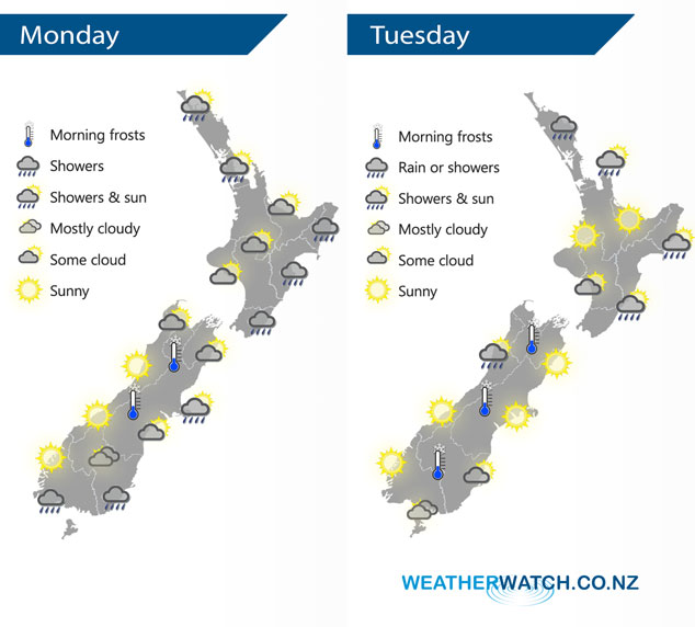
A ridge brings mainly settled weather to the South Island today while a decaying front slowly moves northwards over the North Island during the day. Quite anticyclonic on Tuesday, southeasterlies about the far north.
Some cloud and the risk of a shower north of about Auckland today, showers for much of the day along the east coast (Gisborne to Wairarapa). Morning cloud elsewhere in the west clears to mainly sunny weather. Sunny along the West Coast of the South Island, a mix of sun and cloud for most other regions in the east. Skies fairly cloudy about Southland and parts of Otago (mainly further south) with occasional showers.
Rain for Northland on Tuesday, also a few exposed northeastern areas like northern Auckland, Great Barrier Island and the Coromandel. A shower or two continues to skim along the east coast during the day, mostly sunny out west after any morning cloud breaks away. The South Island is fairly sunny, some cloud about North Westland may bring a shower or two however. Skies quite cloudy about Southland, sunnier the further north you move into Otago.
By Weather Analyst Aaron Wilkinson – WeatherWatch.co.nz
Latest Video

Frosts, clearer skies coming – severe weather possible this weekend
High pressure lies south of NZ today and that placement encourages a colder south-east wind into the North Island bringing…
Related Articles
Frosts, clearer skies coming – severe weather possible this weekend
High pressure lies south of NZ today and that placement encourages a colder south-east wind into the North Island bringing…

NZ: 8 Day outlook as gales & rain ease, high pressure builds
Damaging wind gusts and heavy rain will continue to affect some parts of the North Island and brushing Marlborough today…

Pockets of hit & miss heavy rain, snow moves northwards
Low pressure continues to slowly move across the upper North Island and for some that will bring the sun out,…

